Location: Älvdalen Municipality, Dalarma County Map
Height: 410 ft (125 m)
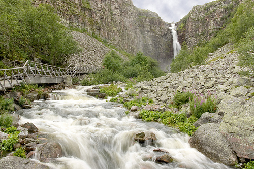
Njupeskär Waterfall, also known as Njupeskär Vattenfall, is one of Sweden's most impressive natural wonders, located in the heart of Fulufjället National Park in the Dalarna region of central Sweden. With a total height of 93 meters (305 feet) and a free-falling plunge of 70 meters (230 feet), it holds the distinction of having the tallest uninterrupted drop in the country, though some estimates suggest Tvillingfallen in Lapland may be taller overall. Situated at coordinates approximately 61°38′N 12°41′E, the waterfall cascades through a narrow, dramatic gorge carved from ancient sandstone, creating a misty, ethereal atmosphere that draws around 100,000 visitors annually. Fed by the Njupån River originating from the high plateau of Fulufjället Mountain, it exemplifies the raw beauty of Sweden's wilderness, blending towering cliffs, lush vegetation, and the thunderous roar of falling water. Often shrouded in fog and surrounded by rare mosses and lichens, Njupeskär is not just a scenic highlight but a symbol of the park's pristine, protected ecosystem, making it a must-visit for hikers, nature enthusiasts, and photographers.
Geological Origins: Ancient Sandstone and Post-Glacial Carving (c.
1.3 Billion Years Ago to ~10,000 Years Ago)
The foundation of
Njupeskär dates back to the Proterozoic era, when the Fulufjället
plateau was part of a vast sedimentary landscape near the equator.
Around 900–1,300 million years ago, wind-blown sand accumulated in
desert dunes and shallow marine environments, compacting into thick
layers of reddish Dalecarlian (or Trysil) sandstone—up to 1,200 meters
thick in places. Ripple marks and mud cracks visible in the exposed rock
testify to these arid-to-shallow-water conditions.
Later intrusions
of diabase (dolerite) dykes, formed about 300 million years ago during
the Oslo Rift period, cut through the sandstone and created more
erosion-resistant veins that support unique vegetation today. Tectonic
uplift beginning around 60 million years ago (linked to broader Scandes
mountain formation and isostatic rebound from glaciation) elevated the
plateau to 900–1,000 meters above sea level, with steep drops of up to
600 meters at its southern and eastern edges.
The waterfall itself is
a relatively recent feature in geological terms. After the last Ice Age,
the region became ice-free approximately 8,000–10,000 years ago. The
Njupån stream, flowing from higher lakes like Storrörsjön toward lower
ones like Lissrörsjön, began eroding the plateau’s rim. Over millennia,
it carved a deep, impressive canyon with sheer cliffs of loose, flaking
sandstone. The powerful spray from the falls now sustains a moist
microclimate at the base, fostering rare mosses, lichens, and plants
that thrive nowhere else in Sweden at this latitude.
Early Human
Presence and Cultural Context (Stone Age to 19th Century)
Human
activity in the broader Fulufjället area stretches back at least 3,000
years, though traces near the waterfall itself are sparse due to the
rugged terrain. Stone Age hunter-gatherers left relics such as a stone
axe near the Fulan River. Iron Age funerary cairns (2–4 meters long,
containing arrowheads and spears) lie just 2 km southeast of
Njupeskär—the only known examples in Dalarna County. An enigmatic stone
formation called Altarringen (a 5-meter oval wall possibly used as an
altar) also exists nearby, though its exact age and purpose remain
uncertain.
The area served as a frontier between Sweden and Norway
from the 13th century (border fixed in 1751 after Sweden captured Särna
in 1644 during the Torstenson War). Early settlements in the valleys
began around 1000 AD, tied to hunting wild reindeer. By the 18th–19th
centuries, transhumance farming led to seasonal cabins (e.g., in
Mörkret), and logging intensified with timber rafting on rivers like the
Görälven. Ancient trails, some predating 1644, crisscrossed the massif
and are still used today as hiking paths. Indigenous Sami cultural
heritage is preserved in the park’s broader management, though the
immediate waterfall vicinity reflects more general Scandinavian mountain
traditions of hunting, fishing, and foraging.
Protection and
Conservation Milestones (1937–Present)
Njupeskär’s modern history is
defined by early and progressive environmental safeguards—one of
Sweden’s pioneering efforts in nature conservation.
1937: The
first formal protection came when 62.2 hectares (154 acres) around the
waterfall were designated a domänreservat (crown reserve). This was a
foundational act; it served as the direct ancestor of Sweden’s modern
natural reserve system.
1946–1970: Expansions followed
rapidly—additional forest reserves along the Göljån and Lövåsen (1946),
growth of the Njupeskär zone to 342.2 ha (1960), redesignation as a
natural park (1964, expanded to 525 ha), and further enlargement to
1,447 ha (1970).
1973: The entire Fulufjället massif (38,060 ha)
received natural reserve status.
1990: Reindeer pasturing was banned
to protect fragile vegetation.
2002: Fulufjället was elevated to full
National Park status (385 km² / 149 sq mi) on 1 August and officially
inaugurated on 17 September by King Carl XVI Gustaf in a ceremony
attended by thousands. It became one of Sweden’s first PAN Parks,
emphasizing both strict preservation and sustainable tourism. The
Norwegian side of the massif gained protection as Fulufjellet National
Park in 2012 for cross-border continuity.
These measures faced
initial local opposition over restrictions on hunting, fishing, and
snowmobiling, but community negotiations secured broad support by the
late 1990s. Today the park uses a zoned management system (60% strict
protection, with trails and limited activities elsewhere) and is part of
the EU Natura 2000 network.
Key infrastructure developments include
the 2010 opening of the Naturum Fulufjället visitor center (with
exhibits on geology, flora, fauna, and cultural history) and trail
upgrades like the 2 km Lavskrikeleden boardwalk to the waterfall
(renovated around 2015 for accessibility).
Modern Significance,
Tourism, and Ongoing Legacy
Njupeskär draws thousands of visitors
annually via an easy, partly wheelchair-accessible trail through ancient
spruce forests and marshes. It is especially striking in early summer
mornings around midsummer, when the sun briefly illuminates the falls,
or in winter when it freezes into ice formations popular for climbing.
The 1997 “storm of the century” (276 mm of rain in 24 hours)
dramatically reshaped the banks, underscoring the dynamic forces still
at work.
The waterfall’s spray zone supports exceptional
biodiversity (hundreds of moss and lichen species), and the park as a
whole protects wildlife including moose, deer, wolves, and lynx. Nearby
stands Old Tjikko, the world’s oldest known living tree (a
9,550-year-old Norway spruce clone discovered in 2005), adding to the
area’s ancient allure.
Location and Accessibility
The waterfall sits at coordinates
61°38′10″N 12°41′18″E, roughly 2 km (1.2 mi) from the small village of
Mörkret and about 25 km southwest of Särna in Älvdalen Municipality. It
occupies the western edge of the Fulufjället massif, the southernmost
extension of Sweden’s Scandes mountains. Fulufjället National Park
(established 2002) spans 385 km² and borders Fulufjellet National Park
in Norway. The park’s visitor center (Naturum Fulufjället) serves as the
main trailhead; a well-marked, mostly flat 2 km trail (or 4 km loop
called Njupeskärsslingan or Lavskrikeleden) leads to it through marshes,
old-growth forests, and gorges. Parts of the trail are
wheelchair-accessible, with boardwalks, shelters, picnic areas, and
interpretive signs.
Topography and Broader Landscape
Fulufjället forms a broad, flat sandstone plateau at 900–1,000 m
elevation, with steep, forest-covered flanks that drop abruptly ~600 m
into surrounding valleys (e.g., Fuluälven to the south and east). The
highest point in the park is Brattfjället at 1,042 m, followed by
Storhön at 1,039 m. The plateau is deeply incised by valleys such as
Bergådalen, Girådalen, Tangådalen, and Göljådalen, and dotted with
shallow lakes (e.g., Stora Rösjön) and extensive bogs (>20 km²).
Two-thirds of the park consists of alpine heaths, mountain moors, and
lichen carpets, giving it a tundra-like character above the treeline.
The Njupeskär area lies on the plateau’s rim, where the terrain
transitions sharply from flat moorland to a precipitous drop.
Geology: Ancient Sandstone Plateau
The underlying bedrock is
Dalecarlian (or Trysil) sandstone, a Precambrian formation dating to
roughly 900–1,300 million years ago. It originated in shallow marine or
desert environments near the equator, when the Baltic plate lay far
south; wind-blown sands compacted into thick (up to 1,200 m),
horizontally bedded strata that are typically reddish (quartz-rich) but
can appear gray, yellow, or brown. Ripple marks and mud cracks preserved
in the rock indicate periodic wetting and drying in an arid setting.
The plateau is cut by younger dolerite (diabase) dykes (~300 million
years old, linked to the Oslo Rift), which are more resistant to erosion
and form prominent ridges or peaks (e.g., Brattfjället). Unique to the
area are greenish Särna tinguanite stones found along watercourses.
Quaternary glaciation left striations, solifluction lobes, stone rings,
and ice-lake terraces, but the primary shaping occurred through
long-term fluvial and periglacial erosion during the Tertiary period. A
massive 1997 rainstorm (276–400 mm in 24 hours) dramatically
demonstrated ongoing erosion, scouring the Göljån valley and exposing
fresh bedrock.
Hydrology and Waterfall Formation
Njupeskär
forms where the Njupån river (or Stora Njupån) flows from
higher-elevation lakes on the plateau (Storrörsjön and similar Rörsjö
lakes) to lower ones (Lissrörsjön). The river plunges over the eroded
sandstone rim in a dramatic cascade:
Total drop: ~93 m (305 ft)
Free fall: ~70 m (230 ft)
This makes it Sweden’s tallest
permanent free-falling waterfall (though some seasonal falls elsewhere
are taller). The water has carved a narrow, steep-walled ravine/canyon
through the billion-year-old bedrock, with loose rocks constantly
flaking from the cliffs due to ongoing erosion and freeze-thaw cycles.
Mist from the plunge pool supports lush microhabitats of moisture-loving
mosses and lichens on the gorge walls.
The river continues downstream
through the gorge, feeding into the broader hydrographic network that
includes Tangån, Girån, and eventually the Västerdal River and Dalälven.
Average annual precipitation is high (~835 mm), with a continental
mountain climate (avg. temp ~1°C, 175–200 days of snow cover). Extreme
events like the 1997 storm highlight the dynamic hydrology.
Landforms and Visual Character
At the rim, the waterfall emerges
suddenly from the flat plateau, creating an “impressive canyon” with
cathedral-like acoustics in the shadowed gorge below. The base features
boulder-strewn pools, rushing rapids, and sheer cliffs coated in spray.
In winter, the falls often freeze into towering ice formations popular
with climbers. The surrounding plateau offers sweeping views of forested
lowlands and distant mountains, while the trail provides overlooks at
the top and (via steep steps) near the base.
Fulufjället National Park, home to Njupeskär, boasts a rich
biodiversity shaped by its boreal forest and alpine zones. The
waterfall's misty environment supports rare mosses, liverworts, and
ferns along the gorge walls, including species like the endangered green
spleenwort and various lichens that thrive in the constant humidity.
Surrounding forests are dominated by ancient Norway spruce, Scots pine,
and birch, with undergrowth of bilberries, lingonberries, and
cloudberries in summer. Higher elevations feature dwarf shrubs and
alpine flowers, creating vibrant displays from June to August.
Fauna
is equally diverse: Large mammals like moose and brown bears roam the
area, while smaller species include foxes, martens, and lemmings.
Birdlife thrives with species such as the Siberian jay, black grouse,
and raptors like peregrine falcons nesting in the cliffs. The river
supports fish like brown trout and grayling, and the park is a haven for
insects, including rare butterflies adapted to the subarctic climate.
Conservation efforts protect this ecosystem, with the park banning fires
and off-trail hiking to preserve fragile habitats.
Njupeskär is accessible via a well-maintained 4 km round-trip hiking
trail from the Fulufjället Naturum visitor center near Särna, about 3
hours northwest of Stockholm by car. The path is moderately easy, with
wooden boardwalks and stairs leading to a viewing platform at the base,
though it's not wheelchair-accessible due to uneven terrain and steps.
Entry to the national park is free, but guided tours (around 100-200
SEK) are available seasonally for deeper insights. The best time to
visit is summer (June-August) for full flow and wildflowers, or winter
for frozen views, though trails may be icy.
Facilities include
parking, restrooms, and a café at the Naturum center, which offers
exhibits on the park's ecology. Tips: Wear sturdy shoes and rain gear,
as the mist can make paths slippery; bring insect repellent in summer.
Allow 2-3 hours for the hike; avoid peak tourist times for solitude.
Combine with nearby attractions like the Old Tjikko spruce (world's
oldest clonal tree) or cross-country skiing in winter. Official website:
www.sverigesnationalparker.se for updates and bookings.