Location: Bohemian Forest, West Bohemia Map
Area: 18.4 ha
Depth: 40.6 m
Černé Jezero or Black lake is situated in Bohemian Forest, West Bohemia of the Czech Republic. Černé Jezero covers and area of 18.4 ha and reaches a depth of 40.6 meters. A single Černý Potok (Black Stream) begins in the lake. The lake was carved out by the glaciers during period of Pleistocene of the Ice Age. The name of the lake is given due to black coloration of its surface. Coniferous trees produce pollen that collects in the lake and make a layer of black sludge several feet deep thus giving its coloration. Thousands of tourists are drawn to Černé Jezero due to pristine nature of untouched forests. Human activity left few marks in these lands. The largest addition is probably pumped storage power plant that was constructed by Skoda Works company in 1929- 30. Today it is a monument of an industrial age.
Location and Broader Geographical Setting
The lake lies at
coordinates 49°10′45″N 13°10′57″E, approximately 6 km northwest of
Železná Ruda and less than 1 km from the Czech–German state border. Its
surface elevation is 1,008 m above sea level. It occupies a north-facing
cirque on the northern slope of Jezerní hora (Lake Mountain, 1,343 m),
directly beneath the dramatic Jezerní stěna cliff, which rises steeply
300–320 m above the water.
The lake sits within the Šumava mountain
range, a fault-block massif forming part of the southwestern border of
the Czech Republic with Germany and Austria. This region features the
largest contiguous forest in Central Europe, dominated by spruce. The
main European continental watershed (water divide) runs along the crest
of Jezerní hora just above the lake. As a result, Černé jezero drains
northward into the Elbe River basin (ultimately the North Sea), while
the nearby Čertovo jezero (Devil’s Lake, only ~2 km away) drains
southward into the Danube basin (Black Sea).
Physical Dimensions
and Morphology
Černé jezero has a distinctive triangular shape, with
its longest side along the base of the Jezerní stěna cliff. Key
measurements include:
Surface area: 18.4–18.47 ha (approximately
0.184–0.185 km²)
Maximum length: ~530 m (0.53 km)
Maximum width:
~350 m (0.35 km)
Shoreline length: ~1,300 m (approximate)
Average
depth: 15 m
Maximum depth: 39.8–40.6 m (making it the deepest natural
lake in the country)
Water volume: 2,878,000 m³
Catchment
(drainage) basin area: 1.28–1.286 km²
These dimensions make it
significantly larger and deeper than other natural lakes in the Czech
Republic (excluding artificial reservoirs).
Geological Origin and
Formation
The lake is of glacial origin, formed during the Würm
glaciation (the last major Pleistocene ice age, Marine Isotope Stage 2).
A mountain glacier carved a classic cirque into the north slope of
Jezerní hora. As the ice retreated around 12,000 years ago, terminal and
lateral moraine ridges dammed the basin, trapping meltwater. Initially
fed by glacial melt, the lake is now sustained by precipitation, two
small southern tributaries, and underground springs. The rocky lakebed
is overlain by a thick (~9 m) layer of organic sediment—primarily pollen
from surrounding trees accumulated over millennia.
The broader Šumava
/ Bayerischer Wald range contains hundreds of mapped glacial landforms
(cirques, cliffs, and moraines), with equilibrium line altitudes during
the Würm period typically between 925–1,145 m. Eastern-facing slopes
(including this cirque) received enhanced snow accumulation due to
prevailing westerly winds, promoting more pronounced glacial erosion.
Hydrology and Water Characteristics
Inflows: Two small surface
streams from the south plus subsurface springs.
Outflow: A short
stream called Černý potok (Black Stream), which flows into the Úhlava
River (a tributary of the Berounka and ultimately the Elbe).
Water
type: Oligotrophic (nutrient-poor, clear, and low in productivity).
Visibility (transparency) reaches 4–5 m.
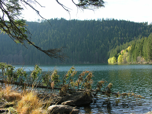
Color: The deep black
appearance that gives the lake its name results from the reflection of
the dense surrounding dark spruce forest.
Ice cover: Typically
freezes from December to April or May, with ice thickness up to 75 cm.
The small catchment area (only 1.28 km²) means the lake responds
sensitively to local precipitation and has relatively stable water
levels.
Surrounding Environment and Ecology
The lake is
completely encircled by dense montane spruce forest typical of the
Šumava highlands. The steep Jezerní stěna cliff to the south creates a
dramatic backdrop, while gentler forested slopes rise on the other
sides. The area forms part of a protected national nature reserve
(together with nearby Čertovo jezero) within Šumava National Park,
preserving its pristine glacial landscape and biodiversity. The lake and
its immediate surroundings are in a strict protection zone, limiting
human access to marked trails. A notable human feature is the oldest
pumped-storage hydroelectric plant in the Czech Republic (constructed
1929–1930), which uses the lake as its upper reservoir.
In the wider
geographical context, the Bohemian Forest here features rolling
plateaus, peat bogs, and other glacial lakes, but Černé jezero stands
out for its size, depth, and striking position beneath the prominent
cliff. Its isolation and protected status have kept it remarkably
pristine.
Černé jezero (Black Lake, German: Schwarzer See) is the largest and
deepest natural lake in the Czech Republic. It lies in the Šumava
(Bohemian Forest) mountains of southwestern Bohemia, about 6 km
northwest of Železná Ruda near the German border, at an elevation of
1,008 m. This triangular glacial lake spans roughly 18.4–18.9 hectares,
measures about 530 m long by 350 m wide, reaches a maximum depth of 40.6
m (average 15 m), and holds approximately 2.878 million m³ of water. Its
dark appearance comes from the reflection of dense surrounding spruce
forests; the water is oligotrophic (nutrient-poor and clear, with 4–5 m
transparency). The lake bed consists of rock overlain by up to 9 m of
silt from millennia of tree pollen accumulation. It drains via the short
Černý potok stream into the Úhlava River (part of the Elbe basin and
ultimately the North Sea). Just above the lake runs the main European
watershed divide; the nearby Čertovo jezero (Devil’s Lake, 2 km away)
drains to the Danube and Black Sea. A dramatic 300 m (up to 320 m) cliff
face of Jezerní hora (Lake Mountain, 1,343 m) towers over its southern
shore.
Geological Formation (Pleistocene to Holocene)
The
lake’s history begins with the last Ice Age. During the Würm glaciation
(the Alpine equivalent of the Weichselian), mountain glaciers carved a
cirque (kar) basin on the northern slopes of Jezerní hora. At the end of
the Tertiary period, cooling climates produced snow avalanches and
glaciers that slid downslope, eroding the rock and depositing massive
moraine dykes of rock and gravel. As the ice retreated around 12,000
years ago (late Pleistocene to early Holocene transition), these natural
dams impounded meltwater, forming the lake. It is a classic cirque lake
fed today by underground springs and small southern tributaries.
Scientific studies of glacial landforms in the area (including moraines
at various altitudes down to ~850 m) confirm multiple phases of
glaciation, with the youngest terminal moraine partially submerged. The
lake has remained largely unchanged since, preserving an arctic-alpine
character rare in Central Europe.
The surrounding Black and Devil’s
Lakes National Nature Reserve (declared 1933, covering ~152–208 ha)
protects this unique post-glacial ecosystem, including rare plants such
as lake quillwort (Isoëtes lacustris) and European bur-reed, plus
specific phytoplankton, zooplankton, and invertebrates.
Early
20th Century: Protection and First Human Intervention
Until the
modern era, the remote high-mountain location saw minimal human activity
beyond occasional forestry or hunting in the broader Šumava region
(historically a mixed Czech-German borderland). In 1911, the landowner
Prince Wilhelm von Hohenzollern, inspired by German botanist Hugo
Conwentz (a pioneer of nature conservation), initiated protection for
the lakes and their rare glacial cirques. This culminated in the formal
declaration of the national nature reserve Černé a Čertovo jezero in
1933 by the Czechoslovak Ministry of Education. The reserve emphasized
scientific and aesthetic value, with early paths (including an 1880–1882
observational trail at nearby Čertovo jezero) allowing limited “soft”
tourism.
In the late 1920s, engineer František Křižík (or a chief
technologist from the State Office in Prague) recognized the lake’s
elevation potential. Construction of the first pumped-storage
hydroelectric plant in Czechoslovakia began in 1929 in the Úhlava Valley
below. Financed by Západočeské elektrárny and equipped with technology
from Škoda Works in Plzeň, the plant opened in 1930. The lake itself
serves as the upper reservoir; water is pumped up from a lower reservoir
(25,000 m³ volume, dammed on the Úhlava) via a 2 km conduit. Original
equipment included a 1,500 kW Pelton turbine (with a smaller 370 kW
Pelton and 40 kW Kaplan added in 2004–2005). It remains operational
today as a historical technical monument and the oldest pumped-storage
facility in the country.
Mid-20th Century: Border Zone and the
Cold War “Operation Neptune”
After the 1938 Munich Agreement, the
area became part of Nazi Germany’s Sudetenland. Post-World War II, the
expulsion of the German population and the 1948 Communist takeover
transformed the border region. From around 1950, Černé jezero lay within
a heavily fortified Iron Curtain border zone (less than 1 km from West
Germany), making public access strictly limited or forbidden under
Czechoslovak border fortifications.
The lake gained notorious fame in
1964 through “Operation Neptune” (or Neptun), Czechoslovakia’s largest
Cold War disinformation campaign, orchestrated by the StB (State
Security) in collaboration with the KGB. Weeks before the “discovery,”
StB agents sank four metal chests into the lake. These were later
retrieved by divers during the filming of a Czechoslovak television
documentary. The chests appeared to contain captured Nazi SS/RSHA
intelligence documents on wartime collaborators. In reality, the
documents were fakes (real papers were supplied later from Soviet
archives; the chests contained blank paper, and corrosion was
artificially aged). The operation aimed to discredit West German
politicians with alleged Nazi ties, revive international interest in war
crimes, and pressure West Germany to extend the statute of limitations
for Nazi prosecutions (set to expire in 1965). The story generated
massive media coverage; the Czechoslovak interior minister publicly
announced the “find.” StB officer Ladislav Bittman (who led the diving
team) defected in 1968 and exposed the hoax in his 1972 book The
Deception Game. Czech intelligence later declassified the files. Many
older Czechs still associate the name Černé jezero with this infamous
Cold War stunt.
Late 20th–21st Century: Tourism, National Park
Status, and Ongoing Protection
Partial relaxation of restrictions
occurred in the 1960s under border-guard supervision, with seasonal bus
services introduced in the early 1970s. After the 1989 Velvet
Revolution, the border opened fully. In 1991, Šumava National Park was
established (incorporating the earlier 1963 Protected Landscape Area),
placing the lake within one of Czechia’s premier conservation zones and
part of the UNESCO Šumava Biosphere Reserve. The reserve’s strict rules
protect its pristine oligotrophic status and rare species; swimming,
boating, and off-trail access are prohibited.
Today, Černé jezero is
a popular but regulated hiking destination. Marked trails (red from Malý
Špičák, yellow educational path from Špičácké sedlo) lead to it, often
combined in a loop with Čertovo jezero. Since 2018, a tourist train from
Železná Ruda (capacity 60, wheelchair-accessible) has improved access.
The hydro plant continues limited operation. The lake has inspired Czech
cultural works, including poems by Jan Neruda (Romance o Černém jezeře),
Adolf Heyduk, Jaroslav Vrchlický, and music by Antonín Dvořák (Ze
Šumavy). While no single dominant folk legend attaches specifically to
Černé jezero (unlike the devil-themed tales of its neighbor), its dark,
reflective waters and dramatic setting have long evoked mystery.
After 1950, the lake was included in the border zone and inaccessible
to the public. In the 1960s, it was made available again under the
supervision of the border guards. In the early 1970s, ČSAD bus service
began to be provided here seasonally. For example, a bus from the
municipal public transport in Klatovy was used for it on weekends, and
later a Škoda 706 RTO bus from the municipal office in Železná Ruda. The
operation of the line was terminated around 1989 in connection with the
increase in the local nature protection regime.
From August 7 to
28, 2010, a special bus line under the number 439040 from the parking
lot in Špičácké sedlo with four pairs of connections per day operated by
the gas bus SOR CN 12 EKOBUS was renewed by ČSAD buses Pilsen on the
order of the city of Železná Ruda, the tariff and transport conditions
announced by the city apply Iron ore. The operation of the line was made
possible by the exception and conditions set by the Administration of
the Šumava Protected Area, valid for four years for the period from June
to September. The city has been negotiating with the PLA on the
introduction of transport since 2008.
Since 2018, the town of
Železná Ruda has been running a tourist train that takes up to 60 people
directly to the lake several times a day. It starts in the morning from
the center of Železná Ruda, continues around Černé jezero - Špičácké
sedlo, and returns to Železná Ruda in the afternoon. The train is
adapted for transporting wheelchairs and is primarily intended for
ZTP/TP.
The red-marked pedestrian route of the Club of Czech
Tourists leads around the lake from Malé Špičák, continuing further to
the northwest. The yellow-marked walking route starts here, along with
the educational trail NS Špičák – Černé jezero and the cycling ridge
route 2055 to Špičácké sedlo. The cycling route from Černý jezero
continues together with the red route to the northwest.