Location: North Bohemia Map
Area: 79 km²
Official site
Pravčická gate
Open: Apr- Oct: 10am- 6pm
Entrance fee: 75 CZK for adults
25 CZK for children (6- 14 years)
Ceske Svycarsko National Park is
situated in North Bohemia of the Czech Republic. Its name is translated as
Czech Switzerland for its picturesque landscapes, dense forests and
beautiful geological formations. Ceske Svycarsko National Park
covers an area of 79 km². One of its most
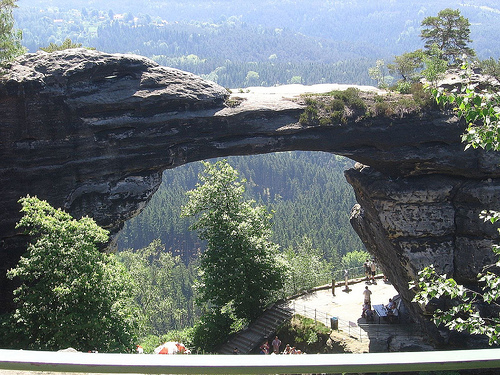
famous and most visited sites is a Pravčická gate. At 16 meters high
and 16.5 meters wide it is the largest natural rock arch in Europe. It is
prohibited it climb the formation. Although it might appear sturdy and
permanent it is not. Pravčická gate is composed of sandstone left from the
time of Mesozoic era then dinosaurs roamed the planet. Age takes a toll on
this natural marvel. Erosion have caused parts of the Pravcicka bridge to
collapse so climbing this geological formation is very dangerous and
ultimately stupid. Falcon's nest lodge is that situated near the arch was
built in 1826 and served as a tavern. Today it houses a museum of Bohemian
Switzerland and a restaurant.
Other popular destinations in the Bohemian Switzerland
include valleys of Kamenice and Krinice rivers, tributaries of the Elbe
river. České Švýcarsko National Park has a continuation on the German side of the border
known as
Saxon Switzerland National Park. In case you were curious what genius
came up with these "original" names look no further. Swiss painters Adrian
Zingg and Anton Graff who worked for the Academy in Dresden often came to
the valley of the Elbe river. Since they liked so much, they called the
region after their homeland.
The term Bohemian Switzerland was created based on the name Saxon
Switzerland of the German part of the Elbe Sandstone Mountains in the
18th century and is said to go back to the two Swiss artists Adrian
Zingg and Anton Graff, who may have felt reminded of their homeland by
the landscape.
In the Czech Republic, the terms Děčínská vrchovina
(official geomorphological name, German for example Tetschener Bergland)
and Labské pískovce (Elbe Sandstone Mountains), which are essentially
synonymous, also exist for the region.
České Švýcarsko National Park (also known as Bohemian Switzerland or
Czech Switzerland National Park) protects one of Europe’s most dramatic
sandstone landscapes. Established on January 1, 2000, it covers
approximately 79 km² in the northwestern Czech Republic, northeast of
Děčín. It forms the eastern Czech portion of the Elbe Sandstone
Mountains (Děčinská vrchovina or Elbsandsteingebirge) and directly
borders Germany’s Saxon Switzerland National Park across the Elbe River,
creating the cross-border Saxon-Bohemian Switzerland region.
The park
lies on the right bank of the Elbe (Labe) River, extending toward the
Lusatian Mountains to the east and the Ore Mountains to the west. It
sits within the broader Elbe Sandstone Protected Landscape Area
(established 1972), which safeguards roughly 700 km² of the range. The
core protection targets unique sandstone rock formations, associated
habitats, and old-growth forests.
Geology and Formation History
The park’s geology stems from the North Bohemian Cretaceous Basin, part
of the larger Elbe Sandstone Mountains. During the Upper Cretaceous
(Cenomanian to Santonian stages, roughly 100–90 million years ago), a
shallow sea deposited thick layers (up to 600 m) of quartz sand, clay,
and marl. These later lithified into compact sandstone beds with varying
cementation (siliceous, clayey, or iron-rich).
After marine
regression, tectonic uplift along faults (such as the Lusatian Fault)
and minor basaltic intrusions (e.g., at Růžovský vrch) raised the
plateau. Millions of years of erosion by rivers, frost wedging, salt
crystallization, honeycomb weathering, solution processes, and
joint-controlled fracturing sculpted the landscape. Horizontal bedding
and vertical joints produced characteristic cuboid blocks, terraces, and
free-standing pillars. Some areas show pseudokarst features or collapse
caves. This process created the “rock cities,” gorges, and arches that
define the park today.
Topography and Landforms
The topography
features a deeply dissected plateau with rapid elevation changes, steep
cliffs, narrow ravines, and isolated rock formations rising above dense
forests. Elevations range from the Czech Republic’s national lowest
point at 114 m (374 ft) in the depths of the Elbe Canyon to the park’s
highest point at Růžovský vrch (619 m / 2,030 ft).
Key landforms
include:
Rock cities and pillar formations — Labyrinths of towering
sandstone pillars, towers, and walls (e.g., around Jetřichovice and Tisá
Rocks).
Natural arches — The iconic Pravčická brána (Pravčická Gate),
Europe’s largest natural sandstone arch, spans 26.5 m with a height of
16 m and sits at ~447 m elevation in the Jetřichovice Wall area. A
smaller companion, Malá Pravčická brána, also exists.
Canyons,
gorges, and ravines — Deeply incised valleys with vertical walls.
Plateaus and mesas — Flat-topped rock formations with terraced slopes
due to differential erosion.
Hydrology and River Systems
The
Elbe River (Labe) forms the northern boundary and cuts a steep, narrow
canyon through the sandstone, creating dramatic cliffs and one of the
park’s lowest points. Tributaries like the Kamenice River have carved
iconic gorges. The Kamenice Gorge (Edmundova soutěska / Wild Gorge) and
adjacent sections feature narrow passages with near-vertical walls,
waterfalls, and moss-covered rocks; visitors navigate parts by
flat-bottomed boats. The Chřibská Kamenice stream flows through the
romantic Pavlinino údolí valley. Smaller streams and seeps contribute to
high humidity in shaded gorges.
Climate and Microclimates
The
park lies in the temperate zone of Central Europe. A striking
geographical feature is climatic inversion in the deep gorges and
canyons: cold, dense air pools at the bottoms, creating cooler, moister
microclimates that support subalpine and alpine plant species (ferns,
mosses) at unusually low elevations. Higher slopes and plateaus
experience warmer conditions. This inversion enhances biodiversity and
gives the gorges a distinctly “alpine” feel despite modest overall
elevations. The area experiences typical continental influences with
moderate precipitation, but recent climate change has increased risks
such as wildfires (notably in 2022).
Overall Landscape Character
and Key Sites
The park blends dense coniferous and mixed forests with
exposed sandstone “cities” that tower dramatically above the canopy.
Viewpoints such as Mariina skála, Vilemínina stěna, and Rudolfův kámen
near Jetřichovice offer sweeping panoramas. Other notable features
include rock castles (e.g., Šaunštejn, Falkenštejn) perched on isolated
crags and unique formations like Fire Rock.
České Švýcarsko National Park (also known as Bohemian Switzerland
National Park or Czech Switzerland National Park; Czech: Národní park
České Švýcarsko) is the youngest of the Czech Republic’s four national
parks. It was officially established on 1 January 2000 and covers
approximately 79–80 km² in northwestern Bohemia, along the right bank of
the Elbe River near the German border. It forms the Czech counterpart to
Germany’s Saxon Switzerland National Park (established 1990), together
creating the larger Saxon-Bohemian Switzerland transboundary protected
landscape renowned for its dramatic Elbe Sandstone Mountains.
Geological Origins (Cretaceous Period to Present)
The park’s
extraordinary landscape dates back roughly 90–100 million years to the
Late Cretaceous, when a shallow sea covered the region. Sediments from
this ancient seabed compacted into thick layers of sandstone. Tectonic
uplift, erosion by wind and water, and the carving action of rivers
(especially the Kamenice and its gorges) later sculpted the sandstone
into iconic features: towering rock “cities,” vertical walls,
labyrinths, arches, bridges, and deep ravines. The highest point is
Růžovský vrch (619 m). These formations create a “rock town” that feels
otherworldly, with moss-covered cliffs, fern-filled gorges, and pine
forests.
Early Human Presence and Settlement
Evidence of human
activity stretches back nearly 10,000 years to Mesolithic
hunter-gatherers. The rugged terrain remained sparsely populated in
ancient times by Germanic, Slavic, and Celtic tribes. Systematic
colonization began in the 12th century with German-speaking settlers
from Saxony. Medieval castles (e.g., Šaunštejn, Falkenštejn) guarded
trade routes along the Elbe; some later became hideouts for robber
barons.
By the 15th century, villages like Hřensko (first mentioned
1475) supported timber rafting on the Elbe and Kamenice rivers,
sawmills, and sandstone quarrying. The 18th–19th centuries brought
economic activity: four sawmills in Hřensko, wool and silk dye trading
after steamboats arrived, and mining. Traditional Upper Lusatian wooden
houses still dot the villages.
After World War II, the expulsion of
the Sudeten German population led to predominantly Czech resettlement.
Origin of the Name “Bohemian Switzerland” and Rise of Tourism
The
romantic name emerged in the late 18th century. Swiss artists Adrian
Zingg and Anton Graff, working at the Dresden Academy, were struck by
how the sandstone cliffs and gorges resembled their Swiss homeland
(particularly the Jura Mountains). They and contemporaries began calling
the German side “Saxon Switzerland”; the Czech side soon became
“Bohemian Switzerland.” The name appeared in print by the 1830s and
stuck.
Tourism exploded in the Romantic era (late 18th–19th
centuries). Painters like Ludwig Richter captured the scenery, and
composer Carl Maria von Weber drew inspiration for his opera Der
Freischütz from the wild landscape near Rathen (across the border). By
the mid-19th century, the area attracted large numbers of visitors for
hiking, viewing points (e.g., Mariina skála, Vilemínina stěna), and the
dramatic rock formations.
History of Nature Protection
(1920s–1990s)
Formal protection began in the interwar period:
1920s–1933: First ideas and declarations during the First Czechoslovak
Republic. In 1933, small protected areas were created: Edmund’s Gorge,
Pravčická brána, and Tiské stěny.
1953: Naturalist Jan Čeřovský
proposed large-scale protection in his thesis on Děčínské stěny forests.
1956: Saxon Switzerland Protected Landscape Area established on the
German side.
1963: German author Reimar Gilsenbach proposed a
bilateral nature park.
1972: The entire Czech side (300 km²) became
the Labské pískovce Protected Landscape Area (CHKO Labské pískovce) by
decree of the Ministry of Culture. Smaller reserves (Čabel, Nad Dolským
mlýnem, Růžák) followed in 1973; Babylon in 1992.
1990: Saxon
Switzerland National Park created in Germany, spurring Czech efforts.
1991–1999: Lengthy boundary negotiations amid resistance from forestry
and hunting interests. Act No. 161/1999 Coll. formally established the
national park.
Pravčická brána received additional protections:
declared a Protected Natural Creation in 1963, upgraded to National
Natural Monument in 1992. Due to erosion and cracks, the arch top was
closed to visitors in 1982.
Establishment of the National Park
(2000 Onward)
On 1 January 2000, České Švýcarsko National Park was
declared on ~80 km² (IUCN Category II). It is managed by the National
Park Administration (headquartered in Krásná Lípa) and includes the
Kamenice Gorge, Růžovský vrch area, and core rock landscapes. Zoning
(approved 2002) divides it into three protection zones, with the
strictest (Zone I, 1,736 ha) prioritizing natural processes. The
surrounding CHKO Labské pískovce was reduced to 245 km² as a buffer.
The park joined the EU’s Natura 2000 network and is preparing for UNESCO
Biosphere Reserve status encompassing both the NP and CHKO. It
celebrates its 25th anniversary in 2025 with exhibitions, lectures, and
events through 2026.
Starting from Saxon Switzerland, the rocks in the Bohemian part of
the Elbe Sandstone Mountains finally came into view of the mountaineers.
The first climbing peak in Bohemian Switzerland was opened in 1888 with
the Beckstein in the Prebischtor area. The most important climbing
peaks, all of which were first climbed before the First World War, are:
Großer Prebischkegel, Nonne, Doggenturm, Empor Nadel, Wotanskegel and
Kastenturm. The development was mainly carried out by German climbers
from Dresden and Tetschen-Bodenbach.
After the Second World War,
the area was then systematically developed, primarily by Czech climbers
(e.g. Karel Bělina, the Weingartl brothers). From the mid-1960s, German
climbers from Dresden were again instrumental in further development. In
the 1970s, the remaining climbing targets located in the former border
restricted area were opened up again.
After the establishment of
the Bohemian Switzerland National Park, serious restrictions came into
force for mountain sports. At first, climbing was completely forbidden,
as in all Czech national parks, but later a regulation was made that
allowed climbing at certain times of the year.
Prebischtor, the largest natural sandstone rock bridge in Europe
Edmundsklamm and Stille Klamm, a rocky gorge near Hřensko
Tyssa
Walls, a rock labyrinth
Děčínský Sněžník, the highest mountain in
Bohemian Switzerland with a lookout tower
Rock castle Schauenstein,
robbed castle near Vysoká Lipa
Marienfels, vantage point near
Jetřichovice
Wilhelminenwand, vantage point near Jetřichovice
Rudolfstein, vantage point near Jetřichovice
Paulinengrund (Czech:
Pavlino Udoli), a deeply incised romantic rocky valley crossed by the
Kreibitzbach (Chribská Kamenice).
Rock Castle Falkenstein
Rock
chapel in Všemily
Belvedere near Labská Stráň
Small Prebischtor
Balzhütte (Czech: Na Tokani)
View of the Emperor from the Quaderberg
near Děčín
Lookout tower on Janovsky vrch near Janov u Hřenska
the
well-maintained villages with their half-timbered houses