Location: British Columbia Map
Area: 1,406 km²
Park Info Center
May- Sept daily
Tel. (250) 347 9615
Kootenay National Park covers an area of British Columbia in Western Canada. Kootenay National Park covers an area of 1,406 km². Kootenay National Park is situated in the Canadian Rockies in the Western Canada. It was established in 1920 and originally encompassed an area around Kootenay river. Kootenay National Park is open all year, however campgrounds are open only from early May to late September. The only exception is at the Dolly Varden campground.
Kootenay National Park is located in southeastern
British Columbia, Canada. It is part of the World Heritage. Kootenay
is one of the four contiguous mountain parks in the Canadian
Rockies, with the other three being
Banff National Park, directly to the east, Yoho National Park,
directly to the north, and
Jasper National Park, which does not share border with the
Kootenay National Park. Initially called "Kootenay Domain Park", the
park was created in 1920 as part of an agreement between the
province of British Columbia and the Canadian federal government. It
is part of the natural set called Canadian Rocky Mountain Park that
was declared a World Heritage Site by Unesco in 1984.
Although Kootenay National Park is open all year, the busiest
tourist season lasts from June to September. Most of the camps are
open from the beginning of May to the end of September, while winter
limits are only available for camping at the Dolly Varden campsite.
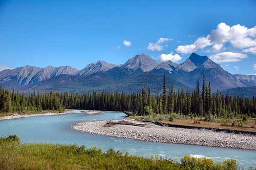
The park takes its name from the Kootenay River, one of the two
great rivers that flow through the park, the other is the Vermillion
River. While the Vemillion River is completely within the park, the
Kootenay River has its headwaters just outside the boundaries of the
park.
Kootenay National Park covers an area of 1,406 km²
(543 sq mi), which is almost the size of Greater London. It is one
component of the Canadian Rocky Mountain Parks World Heritage Site.
The park includes parts of the Kootenay and Park mountain ranges,
the Kootenay River and the entirety of the Vermilion River.
While the park is open all year, the major tourist season lasts from
June to September. Most campgrounds are open from early May to late
September, while limited winter camping is available only at the
Dolly Varden campground.
Contact the park office:
Mid-May to mid-October +1 250-347-9505 or email
kootenay.info@pc.gc.ca
Year-round toll-free +1-888-773-8888 or email information@pc.gc.ca
All visitors stopping in the park (even just for
gas) require a park permit. No pass is required if driving straight
through. Day passes and annual passes are available.
Daily
admission fee (2018):
Adult $9.80
Senior $8.30
Youth and
children under 18 free
Family/group $19.60
Fishing permit
valid at Banff, Jasper, Kootenay and Yoho national parks (2018):
Daily $9.80
Annual $34.30
Parks Canada Passes
The
Discovery Pass provides unlimited admission for a full year at over
80 Parks Canada places that typically charge a daily entrance fee It
provides faster entry and is valid for 12 months from date of
purchase. Prices for 2018 (taxes included):
Family/group (up
to 7 people in a vehicle): $136.40
Children and youth (0-17):
free
Adult (18-64): $67.70
Senior (65+): $57.90
The
Cultural Access Pass: people who have received their Canadian
citizenship in the past year can qualify for free entry to some
sites.
Highway 93, the so-called Kootenay Parkway, crosses the park over a length of 94 kilometers. The highway enters the park via the 1,651 meter high Vermilion Pass, follows the course of the Vermilion and Kootenay Rivers and leads over the 1,486 meter high Sinclair Pass and through the Iron Gate to Radium Hot Springs. The main valley is bordered on the east by the Mitchell Range, on the west the limestone mountains of the Vermilion Range and the Brisco Range rise and limit the park to the Columbia River. The highest mountain in the park is the 3,424 m high Deltaform Mountain, the lowest point in the park is at 918 meters.
The mountain ranges in the park area consist of folded sedimentary
rocks formed by erosion from wind, ice and water. The overturned fold,
jagged ridges, and rounded ridges in the southwestern park area are
typical of the western Rocky Mountains.
Due to the park's
location on the fault line of the Rocky Mountain Trench, hot springs,
the weakly radioactive Radium Hot Springs, emerge in the southwest of
the park. The hot springs, as well as Sinclair Canyon and the Redwall
Faults to the southwest, are significant geological features. Sinclair
Canyon features vertical walls colored red by oxidized iron. Sinclair
Creek once flowed through the canyon, but since 1965 it has flowed in a
concrete channel below the highway. The towering cliffs of the Redwall
Fault, also colored red by oxidized iron, are the best examples of
tectonic breccias within the national parks of the Canadian Rockies.
In the north of the park there are cold springs in whose water iron
is also dissolved. These mineral springs, called Paint Pots, form
pond-like pools colored by brown-red ocher mud. The Paint Pots are not
only geologically interesting, but also of historical and cultural
significance due to their use by First Nations people.
Marble
Canyon, in the north of the park, is an excellent example of a landscape
created by the erosive forces of glaciers and rivers. The rock of the
canyon consists of limestone and dolomite, which resembles marble due to
its white color.
Due to its geographical location, the climate of the park is very different. In the north of the park, 1250 millimeters of annual precipitation falls on the continental divide, and in the southwest of the park, in the rain shadow of the Purcell Mountains, only 350 millimeters of annual precipitation falls. A semi-arid climate prevails at lower altitudes, while a cooler, humid climate prevails in the north of the park. The average temperature in the Kootenay River Valley is −7 °C in winter and the average temperature in July is 22 °C.
The park represents the southwestern region of the Canadian Rockies, a region with diverse landscapes and ecosystems. Due to the difference in altitude, three different ecosystems occur in the park: above the tree line at 1800 meters altitude the vegetation consists of alpine tundra, from 1800 to 1300 meters altitude subalpine meadows and mountain forests predominate, while the wide, relatively warm and dry main valley of the Kootenay River is almost completely forested. Because of the higher rainfall, the forest in the north of the valley consists of a mixed forest of Engelmann spruces and mountain firs, while in the southern part of the park the forests consist of Douglas firs. In the southwest region the forest is no longer closed. Ponderosa pines grow here and fragile ear cacti, a type of Opuntia, grow on sandy places. Several forest fires destroyed large areas of the park, for example in 1926 more than 6,000 hectares were destroyed by fire in the Vermilion River valley, and in 1968 a fire at Vermilion Pass devastated 2,500 hectares. In 2001 a fire raged at Mount Shank, in 2003 at Tokumm Creek and Verendry Creek. The ecological significance of forest fires has now been recognized; The 1968 Vermilion Pass fire is considered one of the most studied wildfires in the Rocky Mountains. Due to the different ecosystems, over 990 plant species, numerous large mammals and 195 bird species are found in the park. Because of the low snowfall in winter, elk, white-tailed deer, mule deer, elk and bighorn sheep live in the southern part of the park year-round. Other mammals include grizzly and black bears, wolves, coyotes, cougars, bobcats and wolverines. Mountain goats are the park's wildlife symbol, with a large population living on Mount Wardle all year round. With the construction of the Grand Coulee Dam in Washington State, salmon disappeared from the park's rivers beginning in 1933. In 1983, spawning sockeye salmon were discovered in the Kootenay River that had migrated upstream from Lake Koocanusa in the U.S. state of Montana.
The park area has been used as a hunting ground by the Ktunaxa
(Kootenay) and Kinbasket (Shuswap) First Nations for 10,000 years. The
hot springs of Radium Hot Springs were already known to the indigenous
people, and the Paint Pots were a sacred place for the First Nations,
where they extracted dye from the ocher mud for dyeing fabrics or for
war paint. The first white man known by name in the area was the
governor of the Hudson's Bay Company George Simpson on his trip around
the world in 1841. From 1912 onwards, plans were made to build the first
road from Calgary to Windermere across the Canadian Rocky Mountains.
Since the province of British Columbia could not cover the construction
costs, an agreement was reached between the province and the federal
government in 1919 in which the federal government took over the
construction of the highway. In return, the province made eight
kilometers of land available on both sides along the road as a national
park. The park was established on April 21, 1920 as Kootenay Dominion
Park, and the highway opened in 1923. The park's name comes from the
Kootenay River, which rises in the park. The first park administration
buildings were built at Radium Hot Springs in 1923, and in the same year
the Canadian Pacific Railroad opened the Vermilion River Camp, today's
Kootenay Park Lodge. The National Park Act of 1930 renamed the park
Kootenay National Park. The park, along with the Jasper, Banff and Yoho
National Parks, has been a UNESCO World Heritage Site since 1985.
At the beginning of 2014, the discovery of a site of Cambrian
fossils in Kootenay National Park, south of the previously known site
near Fields in Yoho National Park, was announced. In an excavation
lasting just 15 days by a team from the Royal Ontario Museum and various
universities, fossils of 50 animal species were unearthed from the
Burgess Shale at the new site. What is remarkable about the
arthropod-dominated assemblage is the high density and diversity of
soft-bodied fossils and the large proportion of new species.
More than nine million people visit the region's seven national parks
every year, with this park in the southwest having to cope with the
least with around half a million visitors.
Tourist facilities
The park has two visitor centers at Radium Hot Springs and the Kootenay
Park Lodge at Vermilion Crossing, which are open seasonally. There are
four campsites in the park, and there are numerous picnic areas with
sanitary facilities along the parkway. More than 200 kilometers of
hiking trails lead through the park. The 34-mile Rockwall Trail begins
at the Paint Pots and heads over the Vermilion Range to Rockwall Pass
before descending back to the parkway via the Ottertail Trail. The
Radium Hot Springs is also within the park boundaries.