Location: Collier, Miami-Dade, Monroe counties, FL Map
Area: 2,354 sq mi (6,073 sq km)
Water depth: 6 in (15 cm) to 3 ft (0.9 m)
Established: 1947
Everglades
National Park is situated across Collier,
Miami-Dade, Monroe counties of Florida, United States. It covers
an area of 2,354 sq mi (6,073 sq km). Everglades National Park is designated as the
UNESCO World Heritage site. It occupies 20% of the state of Florida,
making it the third largest protected biosphere reserve in the
United States after
Death Valley
and Yellowstone
National Park. About 86% of Everglades are declared "wilderness
area". This huge area is served by a fairly small staff, serving
only the main Everglades Visitor Center. Every year nature reserve
is visited by about one million people.
Everglades National
Park is covered by numerous hiking trails. The most famous of
which is Anhinga Trail. Visitors can see up close rare species
of wild birds and animals such as large blue herons and crested
cormorants, as well as American alligators. Keep in mind that
Everglades were saw significant influx of foreign species that
colonized this area. While some species are fairly harmless and
didn't significantly alter biodiversity of Florida, other
species had profound changes to native fauna. Various snake
species brought from Asia became a threat not only to small
mammals, but even humans. This include python snake can
constricts its prey as well as poisonous snakes that can deliver
deadly venom through bites.
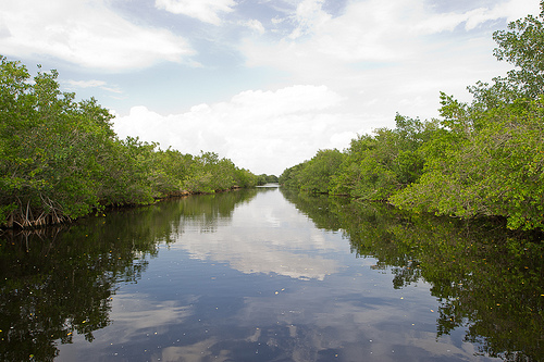
Everglades National Park
contain more than 2,000 different species of plants. Mangrove
coastal forests, freshwater swamps, prairies, cypress dome and
pine woodlands are markedly different from each other in the
composition of plants, animals and birds. There about 36 species
that are designated as endangered or under a threat of
extinction. This includes American crocodile, 4 species of sea
turtles, Florida Panthers and many others. Various invasive
species further wreck havoc of local population of Everglades
animals.
Everglades National Park, protecting more than 1.5 million acres,
is the 3rd largest national park in the lower 48 states, behind
Yellowstone National Park (2nd) and Death Valley National Park
(1st). During the dry season most facilities are open and a full
range of tours and programs are available to enjoy. During the wet
season of June to October, facilities may have restricted hours or
close altogether, and recreational opportunities may be at a
minimum.
The park has four visitor centers:
1 Ernest Coe
Visitor Center, Homestead, ☎ +1 305-242-7700. Nov-Apr: 8AM-5PM;
May-Oct: 9AM-5PM. Open year round, this center offers educational
displays, orientation films, informational brochures and a series of
walking trails a short drive away. A bookstore with film, postcards,
and insect repellent. Restrooms.
2 Flamingo Visitor Center,
Flamingo, ☎ +1 239-695-2945. Generally open from 8:30AM-5PM from
mid-November to mid-April, Summer hours are intermittent and subject
to change. Educational displays, informational brochures,
backcountry permits and restrooms. Public boat ramps are also
nearby. Several hiking and canoeing trails begin nearby. There is a
campground that is open (call +1 305 501-2852 for information), but
in 2018, other lodging is not available due to damage sustained by
Hurricanes Katrina and Wilma in 2005.
3 Shark Valley Visitor
Center, Highway 41 (Tamiami Trail) (25 miles west of the Florida
Turnpike exit for S.W. 8th Street), ☎ +1 305-221-8776. Daily
8:45AM–5:15PM in winter, 9:15AM–5:15PM in summer. Hours subject to
change. In the heart of the "River of Grass", with educational
displays, informational brochures, and guided tram tours. Bicycles
may be rented at the center. Books, postcards, film, insect
repellent, and other items are available for sale. Vending machines
dispense snacks and soft drinks. Restrooms.
4 Gulf Coast Visitor
Center, Everglades City, ☎ +1 239-695-3311. Daily, 8AM-4:30PM in
winter; 9AM-4:30PM in summer. The gateway for exploring the Ten
Thousand Islands, a maze of mangrove islands and waterways that
extends to Flamingo and Florida Bay. Offers educational displays,
orientation films, informational brochures, boat tours and canoe
rentals. Backcountry permits available. Restaurants, stores, lodging
and campgrounds are nearby. Restrooms.
The national park is surrounded, to the east, by the agricultural and
urban areas of Miami, Homestead and Florida City; to the south are the
Straits and the Florida Keys; to the west, the Gulf of Mexico and to the
north, the Big Cypress National Reserve. At the southwestern end of the
park is Lake Ingraham, the southernmost in the United States.
In
the southeastern section of the park, west of Homestead and Florida City
on Highway 9336, is the Earnest F. Coe Visitor Center, which houses the
park's headquarters. About four miles to the west is the Royal Palm
Visitor Center, and a little further west are the Daniel Beard and
Hidden Lake centers. All these centers are surrounded by an area of pine
forests.
Taylor Slough runs from Royal Palm to Florida Bay. A
slough, in the Everglades, is an area of somewhat deeper water where
there is a current, slow but measurable; the sloughs are the rivers of
the Everglades.
About four miles west of Royal Palm on Highway
9336 is Long Pine Key. It is not actually an island, but a camping area
among pine forests. Four miles further is the Pahayokee Overlook, a
raised viewing platform overlooking the park to the north.
Continuing south, Highway 9336 crosses a large cypress swamp. At the
outer edge of this marsh is the Mahogany Hammock, a path that leads into
the park. Further south you come to the swampy mangroves on the coast.
Hidden among the thousands of mangroves are hundreds of small lakes and
rivers that flow into the Florida Straits. The swampy estuaries in this
area are the only places in the United States where crocodiles can be
found, although they are very rare. Manatees are also found in these
estuaries, visible at the surface on cool fall mornings. The road ends
at the Flamingo Visitor Center, the southernmost in the park. It is
located in the arid coastal prairie, north of the Florida Bay. There are
several roads that lead from Flamingo west to Cape Sable, in the
southwestern tip of Florida. The so-called Wilderness Waterway also
leaves Flamingo, a canoe route of about 150 kilometers that reaches the
Gulf Coast Visitor Center in the north. This center welcomes both
visitors from the northwest of the national park and those from the
neighboring Big Cypress National Reserve.
In the northern part of
the park is the Shark Valley Visitor Center. A circular path of about
seven miles allows access to the channel of Shark River (Shark River
Slough), a freshwater current that connects Lake Okeechobee, north of
the park, with the southwest coast. Along the canal are hundreds of
wooded knolls that are home to many of the Everglades' mammal and raptor
species, surrounded by endless stretches of prairie (Cladium) where
waterfowl and alligators can be found. An observation tower allows
observation of the prairie to the south.
The climate of the Everglades is in a transition zone between
subtropical and tropical climates. Like most regions with this type of
climate, there are two basic seasons: a "dry season" (winter) that runs
from November to April, and a "wet season" (summer) that runs from May
to October. . About 70% of the annual precipitation in South Florida
occurs in the rainy season, often as brief but intense tropical
downpours. The dry season sees little rain and humidity is often very
low. The dry season can be severe, and forest fires can be generated at
this time.
The annual range of temperatures in the Everglades is
quite small, ranging from a mean monthly temperature of around 18°C in
January to 29°C in July. High temperatures in the hot and humid season
(summer) usually exceed 32 °C. Frosts are very rare throughout the
region. Average annual rainfall is approximately 160 cm, with most of
the rainfall occurring in the eastern coastal area.
Indigenous people
It is believed that man began to inhabit the
southern part of Florida more than 10 thousand (possibly up to 20
thousand) years ago, when, due to global cooling, the coast of the
peninsula facing the Gulf of Mexico was located approximately 160 km
west of the present. The climate of the region was much more arid, the
abundance of sand and strong winds contributed to the formation of high
dunes. The basis of the diet of the Paleo-Indians who lived in these
places was large mammalian game: saber-toothed cats, three-toed sloths,
spectacled bears. About 6.5 thousand years ago, global warming began,
the subsequent rise in ocean level led to a gradual humidification of
the climate. A significant climatic shift about 5,000 years ago led to
the formation of a swampy area south of Lake Okeechobee, which later
became known as the Everglades. The ancient inhabitants began to spend
less time searching for fresh water, moving from a nomadic to a
sedentary lifestyle. Mammals well adapted to life in the desert have
died out or been exterminated as a result of intensive hunting, and the
diet has shifted markedly towards plant foods and seafood. Despite the
fact that in the middle archaic period (6000 - 3000 BC) the population
of the peninsula decreased, more advanced tools made of limestone, horns
and bones appeared: knives, drills, scrapers, awls and atlatli. In the
late archaic period (3000-1000 BC), the water table came to the surface
in places, and three related Indian cultures formed around the main
sources: Belle Glade, Calusahatchee and Glades.
By the time of
the discovery of Florida by the Spanish conquistador Juan Ponce de Leon
in 1513, its southern tip, where the park itself is located, was
inhabited by two Indian tribes: Tequesta (the Glades culture) and Calusa
(the Calusahatchee culture). The former lived in southeast Florida,
where the main settlement of the same name Tequesta was located at the
mouth of the Miami River, the latter lived in the southwestern part of
the peninsula; the territory of the park served as a natural border
between these two tribes. Unlike Tequesta, which was concentrated in one
locality, Calusa had about 30 villages scattered along the coast of the
Gulf of Mexico. Both tribes visited the Everglades, but due to the lack
of significant sources of fresh water in it, they practically did not
form permanent settlements. Agriculture did not develop in this part of
America; the inhabitants ate fish, shrimp, hunted small game and
collected the fruits of wild plants. The main material for the
manufacture of tools was limestone, in addition, wood, bones and teeth
of animals were used. Shark teeth were used as a cutting tool, spears
and arrows were made from pointed reed stalks. On the territory of the
park, several so-called "kitchen heaps" have been preserved - places
where waste from economic activities was dumped; their study gives
archaeologists and anthropologists an idea of the materials and tools
that were available to the ancient inhabitants. European discoverers
estimated the number of Tequesta Indians at 800 people and Calusa at
2000 people; currently, the National Park Service says about 20 thousand
inhabitants, with the advent of Europeans, lived in southern Florida.
More than 2,000 different plant species, both tropical and temperate,
have been recorded in the park. Dissimilar natural habitats, such as
mangrove coastal forests, freshwater swamps, lowland prairies,
subtropical hammock, cypress domes and pine forests, host different
plants and are markedly different from each other. The climate in the
park is more or less uniform, although the seasons are divided into wet
and dry.
Among the mangroves, it is worth noting the species of
Rhizophora mangle with large aerial arched roots, black mangrove
(Avicennia germinans), white mangrove (Laguncularia racemosa), erect
conocarpus (Conocarpus erectus). On the sea coast you can find piscidia
tree (Piscidia piscipula), mahogany tree (Swietenia mahagony), coccoloba
berry, or sea grapes (Coccoloba uvifera). Elliott pine (Pinus
elliottii), spinosum lyrewood (Citharexylum spinosum), virginian oak
(Quercus virginiana), sticky dodonea (Dodonaea viscose), Guettarda
scabra can be found in pine woodlands. Caroline willow (Salix
caroliniana), golden plum (Chrysobalanus icaco), and swamp cypress
(Taxodium distichum) grow along the canals and in cypress domes. Hammock
is inhabited by stinky sideroxylon (Sideroxylon foetidissimum), virgin
oak (Quercus virginiana), fragrant eugenia (Eugenia foetida), golden
ficus (Ficus aurea), lemon-leaved ficus (Ficus citrifolia), coccoloba
diversifolia, Mexican lavender (Bursera simaruba) , ink tree (Exothea
paniculata), gray simaruba (Simarouba glauca). On the prairies, tall
sword grass (Cladium jamaicense) takes center stage.
There are a
large number of wild orchids in the park, among them the most common
species are Encyclia tampensis, Epidendrum anceps, Epidendrum nocturnum,
Epidendrum rigidum, Oeceoclades maculate, Cyrtopodium punctatum.
In addition, North American erythrina (Erythrina herbacea), punctata
rapanea (Rapanea punctata), Ardisia escallonioides, satin tree
(Chrysophyllum oliviforme), common anona (Annona glabra), Pithecellobium
keyense, thorny xerophytic shrub Randia aculeata, eugenia akhsilaris
(Eugenia axillaris), poisonous plant metopium toxiferum (Metopium
toxiferum), zanthoxylum fagara (Zanthoxylum fagara), wild coffee
Colubrina arborescens, soap tree, or Sapindus saponaria (Sapindus
saponaria), Sideroxylon salicifolium, Trema micranthum, Ocotea coriacea,
Tetrazygia bicolor, psychotria nervosa ( Psychotria nervosa), waxwort
(Myrica cerifera), virgin magnolia (Magnolia virginica), red perseus
(Persea borbonia), Rhus copallinum, Cassine holly (Ilex cassine), wild
tamarind (Lysiloma latisiliquum), bacharis (Baccharis glomeruliflora).
Among the characteristic birds of the park are the short-tailed
buzzard (Buteo brachyurus), the ani-spotted buzzard (Crotophaga ani) and
the American flamingo (Phoenicopterus ruber). Waterfowl abound, such as
herons, ibis, wood storks (Mycteria americana) and roseate spoonbills
(Ajaia ajaja). The carrao (Aramus guarauna) is also present. Among the
birds of prey, the red-shouldered buzzard (Buteo lineatus) and the
osprey (Pandion haliaetus) abound; rarer is the conch (Rostrhamus
sociabilis). Pelicans, waders, terns and skimmers abound in Florida Bay.
In the water courses there are otters (Lontra canadensis), Caribbean
manatees (Trichechus manatus), alligators (Alligator mississippiensis)
and crocodiles (Crocodylus acutus). The park is the only place in the
world where alligators and crocodiles coexist naturally. Numerous
species of turtles are also found here, including the typical
orange-bellied turtle. Also found in the park are deer and the last of
Florida's cougars as well as a large number of snakes.
Circulation
By car: There are only 2 "roads" that cross it: the
Tamiami trail (which connects Tampa to Miami) and Alligator Alley.
There is only one service station for these roads. There are also other
secondary roads: Flamingo trail (Pista Flamenco), Anhinga trail (Pista
Anjinga), etc.
The hydrofoil represents the ideal means of
transport to navigate over the swamps and tour the mangrove swamp, it is
better to take one of these so-called "airboats".
The Everglades
National Park is prohibited to any motorized vessel, but in its
surroundings more or less long tours are offered on private land. The
machine, the "drôle d'engin" as the Cajuns say, are rather rustic. In
reality, it is a wide barge, 5 to 8 meters long with a flat bottom, made
of wood, plastic or aluminum where the goods and passengers are placed
in front (which achieves the view) while in the back part He finds a
kind of "promontory" on which the pilot stands and a sputtering engine
that moves a huge propeller.
The aircraft begins to move smoothly
from the jetty; the already very pronounced backfiring due to free
exhaust. In the large grasses, the first indolently concealed "gators"
are quickly discovered. Thus the boat reaches 55 miles (70 km/h) in a
straight line, it is much more uncomfortable in the turns that it is
necessary to anticipate well in advance. However, nothing (in any case
the trees) impedes the advance of this boat, neither the waters, nor the
mud, nor the grass.
Stay
Hotels: found in Miami, Tampa and
Flamingo City.
Bear Lake, the Flamingo Visitor Center as well as the
Micosukee Indian village are the other places of interest to visit. Here
you can find authentic souvenirs of Indian culture: paintings, spears,
Tomahawks, etc.