II. St. Leonhard
III. Geidorf
IV. Lend
V. Gries
VI. Jakomini
VIII. St. Peter
IX. Waltendorf
X. Ries
XI. Maria Trost
XII. Andritz
XVI. Eggenberg
XV. Wetzelsdorf
XVI. Straßgang
XVII. Puntigam
Location: Styria Map
Graz (formerly also Grätz ) is the capital of
Styria and with 286,292 inhabitants (as of January 1, 2018) the
second largest city in the Republic of Austria. The city is located
on both sides of the Mur in the Graz basin. The metropolitan area of
Graz with 629,161 inhabitants (2017) for the metropolitan regions of
Vienna and Linz , the third largest metropolitan area in Austria.
Greater Graz has been Austria's fastest growing metropolitan area in
the past ten years.
Foundation of Graz dates back to the
Roman Empire. In the 6th century a castle was built here, from which
the name Graz derives (Slovenian "gradec" means "small castle"). The
City Arms received Graz 1245, 1379 to 1619 it was Habsburg royal
seat and resistance during this period several Ottoman attacks.
During WWII, Graz was part of Nazi Germany (along with the rest of
Austria). At the end of the war, Graz was surrendered to Soviet
troops largely intact; the historic old town was not seriously hit
during Allied bombing raids on the city. In 2003 Graz was the
European Capital of Culture ; In 2015 it became the Reformation city
of Europe.
Graz has developed into a university city with a
total of almost 60,000 students (as of 2 January 2017). It was
chosen as the city of human rights and is the sponsor of the Europa
Prize . The old town of Graz and Eggenberg Castle have been a UNESCO
World Heritage Site since 1999 and 2010 respectively. Graz is bishop
seat of the Diocese Graz-Seckau. Since March 2011, Graz has been
part of the Creative Cities Network as a UNESCO City of Design.
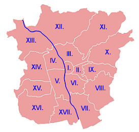
Graz is politically divided into 17 city districts.
| I. Inner city II. St. Leonhard III. Geidorf IV. Lend V. Gries VI. Jakomini |
VII. Liebenau VIII. St. Peter IX. Waltendorf X. Ries XI. Maria Trost XII. Andritz |
XIII. Gösting XVI. Eggenberg XV. Wetzelsdorf XVI. Straßgang XVII. Puntigam |
|
The districts are arranged spirally counterclockwise. Starting from the first district in an easterly direction, the spiral winds around the inner city for a quarter of a quarter . The first six core districts have grown historically, the remaining districts, formerly suburbs, were incorporated in 1938 in the course of the formation of Greater Graz . In 1988, Puntigam split from Straßgang.
General
The historic old town of Graz and its
roof landscape were declared a UNESCO World Heritage Site in 1999
because of their perfect state of preservation and the visibility of
the architectural development in the old town and expanded to "City
of Graz - Historical Center and Eggenberg Castle" in 2010. This
award is associated with the obligation to preserve the historical
legacy with its building ensemble that has grown since the Gothic
period and to harmoniously integrate new architecture. Most of
Graz's sights are in the old town. This extends over the entire
district of the inner city. There are also many historical buildings
outside the old town, mainly in the districts of St. Leonhard (II.)
and Geidorf (III.).
Schlossberg and surroundings
In the
geographic center of the city is the Schloßberg, which served as a
fortress between 1125 and 1809. After the successful defense of the
complex against Napoleon's troops under the command of Colonel Franz
Xaver Hackher zu Hart and the conclusion of peace, the Schloßberg
fortress was blown up. The citizens of Graz bought the clock tower
and the bell tower free, so that both have been preserved to this
day. From 1839 the expansion of the bare rock into a park began. In
addition to the two towers, there are still some remains of the
fortress and listed buildings from that time, including the remains
of the Thomas Chapel, the citizens' and stable bastion and the
casemates (former dungeon). The Schloßberg plateau with its
monuments, not all of which have been uncovered, can be reached via
the Kriegssteig, the Schloßbergbahn, the lift and some footpaths. In
the mountain itself there are tunnel systems several kilometers
long, which were shelters for air raids and bombing raids in World
War II. Today part of it is used for events (“Dom im Berg”) or as a
fairy tale train (“The Graz Fairy Tale Train”). The Mining and
Industrial Railway Museum in Berg is currently not open to the
public due to fire regulations.
The Schloßberg can be
circumnavigated and developed via a path and road network. The tour
begins with the outer Paulustor in the Paulustorgasse of the same
name, the only surviving city gate of the Renaissance
fortifications, which was built by Domenico dell'Allio. The next
building towards the city center is the Palmburg with its mighty
access ramp. Right next to it is the folklore museum and the
inconspicuous Antoniuskirche. The sacred building was constructed
between 1600 and 1602 after more than 10,000 Protestant books were
burned at its site in 1600. This area is called Paulustorvorstadt.
The Palais Saurau with its massive portal and the half-length
figure of a Turk below the edge of the roof dominates the entrance
to the Sporgasse, a steep, narrow street. This is followed by the
former inn "Zur goldenen Pate" with its round oriel, which is unique
in Graz, the former Augustinian hermit monastery and the
Stiegenkirche, the house of the Teutonic Knights and some
representative town houses with shops, before the alley leads to the
main square. The Stiegenkirche, which can be reached via a
staircase, was part of the Paulsburg, the oldest part of Graz's city
fortifications.
Sackstrasse leads north from the main square.
At the beginning of the street is the "Hotel Erzherzog Johann",
followed by the department store Kastner & Öhler, the landscape
pharmacy, the oldest pharmacy in Graz, the inn "Zum Roten Krebsen",
the Palais Kellersberg, the Widow's Palace and the Palais Attems,
Herberstein and Khuenburg . The Palais Attems with its magnificent
facade is "the most important noble palace in Styria", the
Admonterhof is attached to its rear. The Palais Herberstein houses
the “Museum im Palais”; The Graz City Museum and the Pharmacy Museum
are housed in Palais Khuenburg, the birthplace of Franz Ferdinand,
heir to the Habsburg throne who was murdered in Sarajevo in 1914.
Right next to it is the Reinerhof, the oldest documented building in
Graz.
The Kriegssteig and the Schloßbergstollen, a direct
connection to Karmeliterplatz, can be seen from Schloßbergplatz. The
Trinity Church is located across from the square. It belongs to the
building complex of the School Nursing School. Sackstrasse leads
into Kaiser-Franz-Josef-Kai, a street that lines the banks of the
Mur instead of a broken row of houses. The Sackstrasse in Graz
originally consisted of three "sacks", i.e. closed development
zones. Over time, a total of three sack gates, which no longer
exist, broke through the walls to gain living space. For a long
time, this area was considered the most densely populated in Graz.
The valley station of the Schloßbergbahn and town houses are located
on the quay, which leads into the busy Wickenburggasse. Remains of
the old bastion of the third sack gate can still be seen.
Cathedral of Saint Agydlus (Graz)
Mausoleum of Ferdinand II (Graz)
Landesmuseum or Universalmuseum Joanneum (Graz)
Neue Galerie (Graz)
City crown of Graz
The crown of the city of Graz is located at
the foot of the Schloßberg. It consists of four monumental
buildings: the Gothic cathedral (Domkirche St. Ägidius), the
important Mannerist building of the mausoleum with the integrated
St. Catherine's Church from the 17th century, the old Jesuit
University and Graz Castle.
Dom
The Graz Cathedral has
been the cathedral church of the diocese of Graz-Seckau and the
parish church of the Graz cathedral parish since 1786. From 1577 to
1773, the seemingly inconspicuous sacred building with a simple
ridge turret served as a religious order church for the Graz
Jesuits. It is the most important inner-city sacred building in
terms of art and cultural history. Built in the 15th century and was
the court church of the Roman-German emperors. The cathedral was
once connected to Graz Castle by a connecting passage. The main
altar is an important baroque work of art. In the two aisles are the
bridal chests of Paola Gonzaga from the dynasty of Mantua - created
by Andrea Mantegna in the Italian early Renaissance. The outer wall
of the cathedral is decorated with a fresco, the so-called plague
picture.
Catherine's Church and Mausoleum
St. Catherine's
Church with the mausoleum, a Mannerist building, is right next to
the cathedral. It is the burial place of Emperor Ferdinand II
(1578-1637) and the largest mausoleum built by the Habsburgs.
Between the cathedral and the mausoleum stands a bronze sculpture of
the church patron Ägidius on a plinth, which was cast based on a
model by the Graz artist Erwin Huber.
Castle
From 1379 to
1619 Graz was the residence of the Habsburgs. The Jesuit order is
closely linked to the history of Graz. The monks lived in the
canon's courtyard opposite the old and first Graz university.
Graz Castle with the Burggarten is the seat of the Styrian
provincial government. Its construction began in 1438 under Duke
Friedrich V and continued under Archduke Charles II and his son,
Emperor Ferdinand II. A relict from the first, Gothic construction
phase is the extraordinary double spiral staircase from 1499. The
castle gate is integrated into the building, next to the outer
Paulustor the last surviving city gate of Graz.
Center
The
center of Graz consists of the main square, Herrengasse, Färberplatz
and Mehlplatz, parts of Burggasse and Bürgergasse, Schmiedgasse,
Raubergasse, Neutorgasse, Marburger Kai, Andreas-Hofer-Platz and the
Franziskanerviertel with the respective side streets.
The
main square is an irregular and historically grown area with a
market function, which used to extend south to Landhausgasse. All of
the city's tram lines pass through it. On the south side stands the
neoclassical Graz town hall, built between 1889 and 1895 according
to plans by the architects Alexander Wielemans and Theodor Reuter
over an older town hall from 1807. Today it is the seat of the Graz
municipal council. In the middle of the square is the Archduke
Johann Fountain, a work by the Viennese caster Franz Pönninger,
which was unveiled in 1878. The larger-than-life bronze statue of
Archduke Johann towers over an imposing metal base, at the corners
of which four female statues depict allegories of the rivers Mur,
Enns, Drau and Sann. Town houses and city palaces line the main
square: the Weißsche Haus, the Adler pharmacy, the two stuccoed
Luegg houses on the corner of Sporgasse, the Weikhard house with the
grandfather clock of the same name and the Palais Stürgkh.
Herrengasse, a magnificent baroque street, runs between the main
square and the second central square, Jakominiplatz. Here you will
find the country house with its Renaissance arcaded courtyard, the
state armory with the largest collection of early modern weapons in
the world, the so-called "painted house" and the parish church,
Graz's main parish church. Before Herrengasse flows into
Ringstrasse, it crosses Am Eisernen Tor square with its fountain and
Marian column. The eponymous Iron Gate was a city gate of the
Renaissance fortification belt until the 19th century. In the
southern part of Herrengasse, geographically bordered by
Kaiserfeldgasse and Schmiedgasse, the Graz Jewish ghetto was located
until 1439.
From the Stadtkrone you can reach the Grazer
Schauspielhaus, which opened in 1776, on the Freiheitsplatz and via
the Hofgasse and Bürgergasse the alley system around the
Glockenspielplatz with the Glockenspielhaus. At the end of Engen
Gasse you can go through Stempfergasse, a shopping street, to
Herrengasse or see the bishop's palace at Bischofplatz.
The Franciscan Church, the second largest church in Graz, stands
on the east bank of the Mur and is the center of the Franciscan
Quarter. Because of its former island location, the first monastery
settlement in Graz is set at an angle. The course of the so-called
"Kot(h)mur", a sewer, separated the area from the rest of the city
center.
The Joanneumviertel can be reached from the
Franziskanerviertel, located between Raubergasse, Landhausgasse and
Andreas-Hofer-Platz. It consists of two monumental buildings and
houses the main building of the largest Styrian museum, the
Joanneum. The old botanical garden, which had to move to Geidorf,
was once located in the newly designed inner courtyard. The Neutor,
which was demolished in 1884, stood on the site of the new Joanneum
and the post office building by Friedrich Setz. The municipal
building of the city of Graz dominates the streetscape of
Schmiedgasse. The Higher Regional Court of Graz is located at the
southern end of the Marburger Kai.
The old city wall is
visible in a few places above ground: the Glacisstraße and the city
park are reminiscent of the open space in front of the city fortress
in terms of name and location; Remnants of the wall have been
preserved in the peacock garden and in the city park. The layout of
the ring road roughly follows the course of the former moat; in some
corners the position of the former bastions can be seen from the
air. Graz Stadtpark, which covers most of the old glacis, is the
largest inner-city green space. In addition to numerous monuments,
there are the Forum Stadtpark, the Künstlerhaus - Hall for Art and
Media, the music pavilion, the Stadtpark fountain and some natural
monuments. The creation of the park began in 1869 and was opened in
1873 by Mayor Moritz Ritter von Franck. The Graz Opera House, opened
in 1899, was built outside the Stadtpark and in the area of the
city centre.
Bridges and water related
The description of
the bridges and footbridges in Graz is limited to those that cross
the Mur river or, in one case, only accompany it. (For other waters,
see also: Grazer Mühlgang.) Two cable ferries, last in 1958, are
history; Passenger shipping only existed from 1888 until the
steamship Styria (formerly Kühbeck) broke up in 1889 at the Radetzky
Bridge. Since the Capital of Culture year 2003, a “Murinsel”,
actually a pontoon jetty, sitting on the bottom when the water level
is low, has been a technical curiosity. On the left bank about 70 m
above the Kepler Bridge, the Graz gauge was equipped with an
interactive screen in December 2016. The city publishes water levels
of the Graz streams, in particular to monitor the risk of flooding.
Historically twice there was the idea to build a cable car for
passenger transport along and above the river.
The A9 Pyhrn
autobahn crosses the Mur on the northern municipal boundary to
Gratkorn. The Weinzödl power plant (in operation since 1982) is
dammed about two kilometers downstream and feeds the Mühlgang on the
right. 500 m further crosses the narrow Weinzöttlbrücke, which
opened in 1922 and is a listed building - made of concrete, with a
siding in the roadway, originally with gas lights. This is followed
by the Pongratz-Moore-Steg and the Calvary Bridge built in 1989/90
with a towering, blue triangular steel frame between the supporting
structures.
On the right bank at the Kalvarienbrücke at the
house Kalvariengurtel 1 (corner of Floßlendstraße) there is the
plaster painting Floßlend around 1870 by Toni Hafner from 1969 on
the western facade, depicting a raft made of logs lashed with chains
with a rope to a bollard on the bank, behind (upstream) an earlier
wooden bridge of at least five arches.
On the left bank 700 m
above the Calvary Bridge (just below the Calvary Church on the right
bank) and 1 m east of the cycle path that runs alongside the bank
(♁47° 5′ 35.7″ N, 15° 25′ 10.3″ E) a stele (between high bushes) to
the wooden cable ferry "Überfuhr" that used to be operated here from
1934 to 1958. Six concrete steps with four iron anchors can still be
seen as relics on the left bank embankment, fewer on the right bank.
According to the inscription, another crossing existed from "1864 to
the flood of 1873/74" about 200 m below.
The Ferdinandsbrücke, north-west of the Schlossberg, named after
Emperor Ferdinand I, was the first chain bridge in Styria and the
largest in Austria, built from autumn 1833 by the leaseholder of the
ferry, Franz Strohmeyer, based on the plans of the Viennese architect
Johann Jäckl, inaugurated on 19. April 1836 by Prince Bishop Roman
Sebastian Zängerle. It was renamed Keplerbrücke in 1920 in honor of
Johannes Kepler, who lived and researched here for six years. In 1963, a
new bridge was built with steel girders, the underwater side of which
was opened to cyclists around 1993 and widened at the expense of the
roadway. In 2006, the heavily used route for cyclists and pedestrians
along the left bank was crossed under the longest bridge structure in
Graz and named Elise-Steininger-Steg after one of the first Graz
cyclists. The steel support elements are non-slip coated with epoxy
resin quartz sand. One of the elements of the south ramp is horizontal,
so that wheelchair users and pedestrians can pause. However, the
elements have expansion joints up to 30 mm wide. The gap, which became
even wider in the confusing north curve, was covered by a slippery,
smooth NiRo sheet metal, later replaced by a corrugated one, the bumping
hump remains. The stainless steel railing with vertical braces features
a handrail with laser-sharp-cut brackets that will cut the skin of
fingers.
Downstream lies the Murinsel. The tourist attraction and
partially covered "island" is actually a steel pontoon bridge with a
large oval float that rests on skids on the bottom at low tide. So that
the “island” is completely surrounded by water in this case, too, a
small sill was built across the entire river a little below. A curved
footbridge leads from the right bank to the bow of the float, which –
oblong-oval, in the middle of the river – hangs on a steel cable that is
anchored in the river and is checked by a diver about once a year. From
the stern, a bridge that curves in the opposite direction leads to the
left bank. Viewed along the axis of the river, the jetties run in a
V-shape towards the middle of the river at low tide. The floating body
rises with high tide, in extreme cases higher than the bridgeheads of
the jetties on the banks. The transverse thrust of the webs twists the
island slightly around the vertical axis. The footbridges can be reached
by stairs, on the left also by lift, from the right also by ramp and are
signposted as footpaths.
Shortly afterwards - in the extension of
the Schlossbergplatz - follows the Erich-Edegger-Steg. This wheel-foot
bridge was named after the local politician and fighter for soft
mobility in 2003 and only received sufficient vibration absorbers around
2010 and was completely renovated in 2020.
Then comes the
Archduke Johann Bridge (until around 2013: Main Bridge). The former ford
here was the first and over 400 years the only Murbrücke in Graz. In
1843 the city built a chain bridge, which was replaced by an iron
structure in 1892. In 1918 the Franz Carl Chain Bridge was renamed the
Main Bridge. A simple new construction of the main bridge with a wide
carriageway was carried out in 1964 with the intention of demolishing a
row of houses in the narrow Murgasse and allowing motor vehicle traffic
to cross the main square. The figures of Austria and Styria, which stood
on the bridge, are located in the city park, bronze decorations came
into private hands and were again offered to the city for sale around
2003 and 2014. A bronze ornament has been on display on the left bank
under the bridge since around 2003, as well as a stone salvaged from the
Mur. A terrace was concreted here around 2002, from which a striking
staircase leads up to near the left bridgehead on the underwater side,
downstream the Murpromenade, which has been developed as a footpath with
stone benches, leads. The modern main bridge was completely renovated
around 2006: The railings were made of NiRo steel as a gently arched,
profiled railing plus wire rope net, which is now full of "love locks".
The sidewalks were widened, the step on the upstream side was lowered to
3 cm and the tram route was routed parallel to the southern edge of the
sidewalk in a more cycle-friendly manner. It was not until 2013 that the
almost car-free bridge was renamed to Archduke Johann Bridge. In 2003,
the Paddle Rodeo World Championships took place on a wide water cylinder
created by stone sizing on the underwater side between the central
pillar and the left bank.
In 2018-2019, the Graz Mur power plant
in Puntigam and the central storage canal (ZSK) (left) along the bed of
the Mur with several feed canals were built across the bed of the Mur up
to the Tegetthoff Bridge. A resistance movement of Murschützen, who set
up camps and tree houses and called for a referendum, could not prevail.
The Puchsteg bridge from around 1940 (between the Liebenau camp and
Puchwerk) had to be demolished in 2019 so that the Mur remained
navigable for the fire brigade when the water level had been raised by
around 5 m. A new, covered Puch footbridge was built in 2019/2020 about
100 m above at the level of Sturzgasse. Radlobby Argus managed to
increase the lane width to 3.50 m compared to the plan of 2.50 m. A
shallow water zone with two concrete piers was built below on the left.
The Augarten Bay was built at the same time. A small tributary was
created above the Augartensteg on the left, the steep embankment was
removed and the park was lowered here in an arena-like manner. The main
cycle route was relocated, experienced a kink and a detour.
From
the root of the reservoir, the current speed is reduced, making upstream
paddling and rowing easier, but leading to the deposition of sediment in
the river. In autumn 2020, work began on the new construction of the old
boathouse at Marburgerkai. Instead of sacrificing the power plant output
to the left of the Puntigam power plant, plans are underway to use the
gradient to the left below the Murinsel in order to generate jets of
water with a roller for playboating.
Downstream follows the
Tegetthoff Bridge, completed in 1975, and the listed Radetzky Bridge.
With the support of a rope suspended from the Gehradweg (GRW) bridge,
surfing on boards and playboating has been practiced in a roller in the
left half of the river since about 2000 when the water flow is suitable.
The Puntigam power plant on the Mur, which began construction in 2017,
will dam this roller, as well as the location at the Archduke Johann
Bridge further up. Boating was banned as early as mid-December 2017 with
the construction of the construction road on the left bank of the river
for the Central Storage Canal (ZSK) up to around the Radetzky Bridge
extended to beyond the boathouse on Marburgerkai, so that the Christmas
paddling of the Canoe Club Graz (KCG) on December 16, 2017 from the
Weinzödl power plant ended for the first time before the
Erzherzog-Johann Bridge by exiting at Murbeach. Below this is the
Augartenbrücke, the last existing concrete arch bridge, and the
particularly complex Augartensteg for pedestrians and cyclists, which
was built in 2003 to save costs without the connecting structure planned
by the architects for the left bank. The supporting structure was stored
as a whole on rollers on the right bank, supported by a crane hoist and
brought across the river from a walking mechanism at the front. After
being placed on the bridgeheads, the four slightly sloping arches were
braced by means of two hydraulic cylinders acting on steel compression
struts, which were located above the middle of the river and on the
right and left slightly below the roadway, which were finally fixed with
a weld seam. It was only around 2010 that this footbridge was
supplemented by a gravel path to the east through the park, on which
even cycling was allowed.
After the Augartenbad that follows the
Augarten, the Berta von Suttner Peace Bridge, which was first named
(around) 1984, crosses the Mur. It has four lanes, is heavily used by
vehicles and is connected on the right bank with a loop and underpass
without crossing. On the underwater side, it has a cycle path under the
main lane with a sidewalk, which is characterized by poor visibility on
the left bank, which is prone to accidents, and on the right bank by the
lack of cycle traffic connections upstream. For decades, the police and
road authorities have tolerated the fact that the majority of pedestrian
traffic also takes place here.
Only one junkyard length (near the
left bank) further and after the snowfall on the right crosses the
railway bridge of the Styrian Eastern Railway. For boaters and swimmers
- the Mur has had good bathing quality for decades - dangerous steel
profiles towering in the area of a former central pillar were removed
by the fire brigade around 2009.
About 1 km downstream, the
Steweag/Steg pipe bridge, which is closed to the public, runs two
insulated district heating pipes plus high-voltage cables from the Mur
district heating plant (Puchstraße), which went into operation in 1963.
Almost 1 km further and a little south of the Sturzgasse the Puchsteg
ran across the river. With girders and railings made of steel, both clad
in wood, it was probably built in 1942/1943 for the forced laborers of
Camp V, which was built in 1940, to enable them to reach the Puchwerk
west of the Mur more quickly, although it was signposted as "built in
1949". It was released for public use in 1949 after a general overhaul
and renovated around 2013 as a pedestrian and cyclist bridge. The
footbridge was about 75 m long, the Mur here at Mittelwasser about 45 m
wide, the bridgeheads were formed by U-shaped to trapezoidal reinforced
concrete foundation walls and short road ramps with a 10-15% gradient.
The two piers made of painted steel lattice supports stood in the water,
were almost two-dimensional trapezoidal - a few decimeters narrow from
the point of view of the water flow, from the point of view of the jetty
axis as wide as the jetty at the top - about 2.5 m, at the bottom in the
water about 10 m wide. On the upstream, sloping front edge and part of
the sides, the pillars were covered with wooden planking as protection
against direct impact and getting caught by any flotsam, ice in winter
or trees at high water. In 2017, by March 15, the trees on both banks
were cleared on a stretch around the Puchsteg to build another Mur power
plant near the Olympiawiese. By December 2017, the construction road for
the central storage canal was built in the water on the left bank
upriver to around the Radetzky Bridge, as well as a bridge with a load
capacity of 90 t up to the middle of the river just below the Radetzky
Bridge. In this context, the Puchsteg was demolished in June 2019. The
opening of a new footbridge over the Mur, originally planned for the
summer of 2019, had to be postponed due to delays in the usage
agreements for the properties required for this and was finally carried
out on July 10, 2020. However, the usage contract with the owner of the
soap factory is limited to five years for the time being.
From
around 2021, the power plant is to offer another crossing point for
pedestrians and cyclists, but on the left bank the cycle route will take
a detour. The power plant operator Energie Steiermark promised the new,
young chairman Marcel Bloder of the Graz Kayak Club KCG a training
course with a natural gradient for various types of water sports
directly to the left of the power plant - by the hour and for a fee. The
Puchsteg footbridge above the planned power plant site was too low for
fire-fighting boats to be able to drive under it, so it had to be
removed. The new building is about 220 m further north in the line of
the Sturzgasse and has been significantly raised, which in connection
with the Mur power station will mean that the river-crossing network
meshes for pedestrians and cyclists will be somewhat denser in this area
in the future.
This is followed by the Puntigamer Bridge, a
four-lane road bridge that was rebuilt in 1995/96 and will carry even
more car traffic with the southern belt (construction start in 2014,
opening on May 19, 2017). On the south side, it is equipped with a
footpath and cycle path at road level, separated from it by a tiered,
orange-tiled concrete wall. Fragments of the previous structure lie
downstream of the bridge, where there is rougher water, swells and even
an eddy at one point just to the right of the middle of the river.
(Status 2017, with a clearing and deepening for the underwater of the
upcoming power plant is to be expected.)
About 500 m south of
Auer-von-Welsbach-Gasse, where there was a municipal gas works, the iron
gas pipe footbridge (built in 1951), also covered with wood, leads over
the river with two piers for cyclists and pedestrians, on the left bank,
with a ramp bent at right angles upstream connected to the Uferweg (GRW
only upstream) and the parallel Murfelderstraße. On the right bank, the
legal possibility to skate ends here, actually only moving walkways on
the edge of the sidewalk-free road would be allowed from here. This is
roughly the root of the reservoir of the Gössendorf Mur power plant,
which only went into operation in 2012. The motorway bridge that will
soon follow is just south of the city limits in Gössendorf or
Feldkirchen near Graz, exactly 1 km further from the power plant
mentioned.
Two of the eleven city gates in Graz have been
preserved: the Burgtor as a section of Graz Castle and the outer
Paulustor at the end of Paulustorgasse. While the Paulustor is the only
surviving rampart gate of the historic late Renaissance fortification
belt, which was planned by the master builder Domenico dell'Allio, the
Burgtor cannot be assigned to either the medieval or the modern city
fortifications.
Nothing remains of the medieval wall. The two
Murtore in Murgasse were demolished in 1837, followed by the inner
Paulustor in Sporgasse in 1846, the three Sacktore in Sackstrasse have
not existed since the 19th century. The Renaissance wall of the city
gate of the same name stood on the square by the Iron Gates. Like the
Neutor, demolished in 1884 as the last of the old gates, it resembled
the outer Paulustor. The Franzenstor at the mouth of the Burggasse in
the Roseggergarten lasted the shortest. The decorative arch erected in
1835 was removed again in 1856. The demolition of the Graz city gates
was legitimized by the increased volume of traffic and increased
construction activity. After the fortifications were demolished in the
middle of the 19th century, they lost their protective function.
Until the annexation of Austria in March 1938, a pavement toll was
levied at the Graz city gates (this toll had been abolished almost
everywhere in Europe in the 19th century).
Eggenberg Castle
With more than a million visitors a year, Schloss Eggenberg and the
Schlosspark are the most frequented sights outside of Graz city centre.
Eggenberg is considered to be the most important baroque palace
complex in Styria. Its history goes back to the Middle Ages. From 1625
it was expanded into a representative four-wing complex by order of Hans
Ulrich von Eggenberg (1568-1634) and under the direction of the court
architect Giovanni Pietro de Pomis. The castle was directly connected to
the city center via Eggenberger Allee; all that remains of the boulevard
is a small section with avenues in the immediate vicinity of the palace
and a street name.
Schloss Eggenberg is designed according to a
cosmic number symbolism. The four corner towers stand for the four
cardinal points and the four elements. The facility has 365 exterior
windows for the days of a year. On the second floor, the Beletage, there
are 52 exterior windows for the weeks of a year. Each floor in the house
has 31 rooms for the maximum number of days in a month. On the second
floor, 24 state rooms are arranged in a ring, symbolizing the hours of a
day. The concept is intended to commemorate the Gregorian calendar
reform of 1582.
A cycle of 24 state rooms with original
furnishings from the 17th and 18th centuries is one of the most
important ensembles of historic interiors in Austria. Rarely has an
interior of comparable quality been preserved in such a complete way.
Its focal point is the stuccoed planetary hall with the cycle of
paintings by Hans Adam Weissenkircher.
The publicly accessible
castle park was designed together with the castle. He often changed his
appearance throughout the story. It is one of the few historic gardens
in Austria that are under monument protection. At the north corner is
the planet garden, which was newly laid out in 2000. Free-roaming
peacocks live in the castle park.
sacred buildings
In Graz, as
in most cities in Catholic Austria, there are numerous sacred buildings.
The oldest churches in the city are the Leechkirche near the University
of Graz, the Stiegenkirche as part of the historic Paulsburg in
Sporgasse and the Rupertikirche in Straßgang. The tallest church
buildings are the neo-Gothic Herz-Jesu-Kirche made of brick and the
Franziskanerkirche - the lower part of the tower of which was once part
of the Graz city wall. At 109.6 m, the Herz-Jesu-Kirche is the third
highest church in Austria and the tallest building in Graz. In the same
district opposite the LKH Graz is the parish church of St. Leonhard,
first mentioned in 1361. At this point, the Meierhof Guntarn stood in
the Middle Ages as Graz's first settlement outside of the inner city.
There are numerous religious branches in Graz, many of which were
dissolved in the course of the Josephine reforms of 1783. There remained
mainly monasteries dedicated to nursing and education. A Franciscan
monastery has been preserved in the city center since the 13th century,
on the opposite bank of the Mur is the Minorite monastery with the
baroque Mariahilferkirche. In the Sackstraße, opposite the
Schloßbergsteig, is the Trinity Church, until 1900 the church of the
former Ursuline convent. The Antoniuskirche is located in the
Paulustorgasse next to the folklore museum.
The larger complexes
in the city of Graz include the Dominican convent in the
Münzgrabenstrasse, the Lazarist monastery in the Mariengasse, and the
monastery of the Sisters of Mercy right next to it. The Brothers of
Mercy maintain two hospitals in Graz: one in Marschallgasse (further
expansion from 2019) and one in Eggenberg. Women's orders dedicated to
nursing are the Elisabethines in the district of Gries and the Sisters
of the Cross with a convent and private clinic in Geidorf. The Ursulines
in Leonhardstraße, the school sisters at the foot of the Schloßberg and
in Eggenberg, as well as the school and monastery of the Sacré Coeur
Graz are active in the school.
In Geidorf there is the
Grabenkirche as the monastery church of the Capuchin order, the Church
of the Redeemer on the grounds of the LKH Graz and the Church of Maria
Schnee as part of the Carmelite monastery in the Grabenstraße. Next to
the men's monastery is the Carmelite monastery with the church of St.
Joseph, whose first convent on the former Fischplatz (today
Andreas-Hofer-Platz) was dissolved in 1782 and the building was
demolished in 1934. In addition to the Church of the Sisters of the
Cross with the private clinic, a modern sacred building has been
preserved in Geidorf with the Salvator Church.
The Graz Calvary is located in the fourth district of Lend. The
complex on the Austein was founded in the 16th century and managed by
the Jesuits. The high baroque Calvary Church with the Holy Stairs and
the Ecce Homo stage and the numerous chapels are particularly worth
seeing. Also worth mentioning in the same district are the Church of
Mercy and the Church of St. Mary near Graz Central Station.
In
Gries there are important Gothic and Baroque church buildings such as
the Church of St. Andrä, the Welsche Church on Griesplatz and the
Bürgerspitalkirche. In addition to the baroque Karlauerkirche and the
central cemetery church in neo-Gothic brick style, there are some modern
church buildings: St. Lukas with its unusual interior, St. John as part
of the Trieste settlement, as well as the church and parish center of
Don Bosco, in whose buildings a toll booth and a powder magazine were
housed. The Jakomini district is primarily characterized by the modern
church building of the Münzgrabenkirche and the Josefkirche.
A
sacred center in Graz is the outskirts of Mariatrost. The Mariatrost
Basilica, a nationally known and baroque pilgrimage church on the
Purberg, has officially been the destination of large streams of
pilgrims since 1714. A miraculous statue of Mary from the Rein Abbey in
Eisbach is venerated. The construction of the sacred building lasted
from 1714 to 1779. After the Josephine reforms, the monastery wings were
used as stables. From the mid-19th century until 1996, the Franciscans
resumed the pilgrimage tradition. In the same year, Pope John Paul II
appointed Mariatrost a minor basilica. In 1968 the Mariatroster
Declaration was published in the pilgrimage church.
In addition
to the Mariatrost Basilica, there are two other sacred buildings in the
district: the Mariagrüner Kirche, which is considered the most important
ecclesiastical foundation by a citizen of the city of Graz. Louis
Bonaparte, Napoleon's brother, often visited the church building on his
walks. In 1873 the Styrian writer Peter Rosegger married his first wife
in the Mariagrüner Church. On the other hand, the modern Church of the
Annunciation in Kroisbach, which was integrated into a housing estate
and consecrated in 1974.
In the district of St. Peter, the parish
church of St. Peter is visible from afar. In the northeast of Graz you
can visit the church of St. Ulrich and the associated spring sanctuary,
the parish church of St. Vitus and the church of the Holy Family in
Andritz. There is a sacred building in each of two districts: St. Paul
in the Eisteichsiedlung in Waltendorf and the Bruder-Klaus-Kirche near
the satellite town on the Berliner Ring in the Ragnitz.
On the
right bank of the Mur, in the districts of Gösting and Eggenberg, you
can see the Church of St. Anna, the Castle Church of Eggenberg Castle,
the Fourteen-Nothelfer Church, the modern Church of the Guardian Angel,
the Church of St. Vincent and on a ridge in Wetzelsdorf the Church of
St. Johann and Paul . In the southern district of Straßgang there are
other sacred buildings in Graz, such as the Church of Maria im Elend,
the Schlosskirche St. Martin, the somewhat remote Florianikirche on the
Florianiberg, the Elisabethkirche and the aforementioned Rupertikirche.
In the youngest district of Graz, Puntigam, there is the parish church
of St. Leopold, built in 1967, and the institutional church of the
southern location in the LKH Graz Süd-West.
The Heilandskirche,
located near the Graz Opera House, is the largest evangelical church in
the city of Graz. The current building was erected in the historicist
style from 1853, after a Protestant house of prayer had been located
here since 1824. It is part of a building complex with parish buildings
and the Martin Luther House. The Evangelical Church also includes the
Kreuzkirche on the edge of the Volksgarten, whose parish home is the
Mühl-Schlössl, the Christ Church in Eggenberg, the Evangelical Church of
St. John in Andritz and the Church of the Redeemer in Liebenau.
In addition to the Catholic and Protestant church buildings in Graz, the
Old Catholic Church can be found on Kernstockgasse, the Coptic Church on
Wiener Strasse and centers of various denominations scattered throughout
the city, including a parish hall of the Church of Jesus Christ of
Latter-day Saints (Mormons) in Eggenberg.
Graz also has a synagogue. The old Graz synagogue was built in 1892
and belonged to the Jewish community with its 2,500 members. It was a
successor building to the synagogue in the former Jewish quarter in
downtown Graz. In the so-called Reichskristallnacht from November 9th to
10th, 1938, the prayer house was burned down and the entire area leveled
to erase the memory of the synagogue. All Graz Jews were deported to
Vienna and Graz was declared the first “Jew-free” city in the Ostmark.
Until 1998 there was only a lawn with a memorial stone on the site of
the destroyed synagogue. The new Graz synagogue and community center
were built in 1998 using the old brickwork. In August 2020,
pro-Palestinian graffiti was applied to both buildings and windows were
smashed. The mayor was attacked with a baseball bat.
secular
buildings
On the northern outskirts of Graz are the castle ruins of
Gösting, a ruin with a very good view, from which the Mur Valley north
of Graz was once controlled. In the 10th and 11th centuries there was a
previous structure on the Frauenkogel at this point, the remains of
which, like the castle, are listed. Gösting Castle itself dates back to
the 12th century and was part of a chalk fire warning system designed to
warn the population of any threats. In 1723 the castle was destroyed by
lightning, today the ruins are a tourist destination. After the
destruction, the Counts of Attems built the baroque castle of Gösting as
their new seat.
The largest Art Nouveau building complex in
Austria is located in the east of the city, the LKH University Hospital
Graz. It was "regarded as the most modern hospital on the continent at
the time and was often even referred to as a wonder of the world".
However, the relatively long distance from the city center aroused the
displeasure of the Graz citizenry. The building complex is connected by
an underground tunnel system. Each medical department has its own
building. Modernization measures were carried out over time. In the
vicinity of the hospital you will also find the Rettenbachklamm, a
year-round accessible gorge in the city area, the Leechwald local
recreation area, the artificially created Hilmteich with a castle and
the Hilmwarte.
Outside the city center there are relatively few
palaces, most of which are publicly owned. In St. Leonhard, on the edge
of the city park, stands the Palais Kees, a late classicist building.
Among other things, it housed the k.u.k. corps command. Since a
renovation at the beginning of the 21st century, it has been used as a
student residence. Palais Meran, the former city seat of Archduke
Johann, has been the main building of the Graz Art University since
1963. With numerous palaces and villa complexes, Elisabethstraße is one
of Graz's boulevards from the Gründerzeit. Worth mentioning are the
Palais Apfaltrern, Auersperg, Kottulinsky, Kübeck and Prokesch-Osten and
the Meran houses. The Graz Literature House is located in the Palais
Mayr-Melnhof. Somewhat out of town are the villas Kollmann and Lazarini
(in selection). The Geidorf villa district stretches from
Elisabethstraße via Leechgasse to Schubertstraße.
The Palais
Thinnfeld in the district of Lend is directly connected to the Grazer
Kunsthaus. A special feature of the Palais Wertl von Wertlsberg is its
castle-like character, which is achieved by two polygonal corner towers
and a corner bay window. At the entrance to Dominikanergasse, Palais
Gleispach is the only palace in the Gries district. In all other
districts of Graz there are no palaces, but castles and noble
courtyards.
Since Graz was a popular seat for aristocrats and
higher officials during the monarchy, there are many castles and palaces
in the city. In addition to the numerous palaces in the city centre, it
is above all castles and noble courtyards that characterize the
appearance of Graz in the peripheral areas. In addition to Eggenberg
Castle with its park, the baroque Gösting Castle and Graz Castle, a few
buildings are worth mentioning. In the middle of Geidorf is the
Meerscheinschlössl, a baroque building with what used to be a spacious
park. The Haller Castle and the Lustbühel Castle with an integrated
kindergarten are located in Waltendorf. A cadet school was housed in the
former Liebenau Castle, and the HIB Liebenau has been located in the
premises since the 1970s.
The inner-city palaces include the Messe-Schlössl, the
Metahof-Schlössl near the train station, the Mühl-Schlössl near the
Volksgarten or the Tupay-Schlössl in the former Schönau. St. Martin
Castle and St. Veiter Schlössl Castle are prominently located in the
outskirts, while Algersdorf Castle, Reinthal Castle, Moosbrunn Castle
and Kroisbach Castle are somewhat hidden. In addition to the Graz
palaces, there are a number of surviving noble estates, i.e. residences
that were often exempt from taxes and were run as estates. One example
is the Weisseneggerhof on Esperantoplatz. Most of the facilities are
privately owned.
A special feature is the former hunting lodge
Karlau. It was embedded in the original Karl-Au area and surrounded by a
zoo and the imperial hunting grounds. In addition to water fowl and red
deer, falcons, herons and pheasants were bred in the zoo, released into
the Mur floodplains and hunted. Even today, a number of street names
(Tiergartenweg, Rebhuhnweg, Reiherstadlgasse, Falkenturmgasse,
Fasangartengasse, Auf der Tändelwiese) in the area are reminiscent of
the zoo and hunting grounds. For example, "Tändel" is an old term for
red deer. In the course of its history, the castle was used as a
prisoner of war house, from 1769 as a workhouse, until 1803 it was
converted into a provincial penal house. After many expansions and
conversions, only the core of the Graz-Karlau prison has survived.
monuments and fountains
Graz has a wealth of monuments. The most
prominent (selection):
the Marian columns (1666-1670) at the Iron
Gate, at Karlauplatz (1762) and at Marienplatz (1680),
the plague
columns on Karmeliterplatz (1680), Lendplatz (1680) and Griesplatz
(1680), which were donated by the citizenry as votive columns after
plague epidemics or enemy invasions.
the plague memorial "Am Damm", a
memorial in the form of a chapel from 1680. The increased erection of
such plague columns and memorials around the year 1680 arose from
gratitude for the end of a plague epidemic in Graz, which, with over
3,500 fatalities, took the lives of around a fifth of the city's
population .
The Archduke Johann Fountain (1878) on the main square
with a larger-than-life bronze statue of Archduke Johann and allegorical
depictions of the four rivers Mur, Enns, Drau and Sann was designed by
Franz Pönninger and unveiled on September 8, 1878. Fountain bowls are
bordered at the four corners. The bases are decorated with allegorical
bronze reliefs. The fountain was originally intended to be set up in the
Joanneum Garden or at the Iron Gate. The appearance of some squares and
parks in Graz is characterized by fountains. The Major Hackher Monument
("Hackher Lion", 1909) on the Schloßberg is dedicated to the colonel of
the same name, who successfully defended the Schloßberg against
Napoleon's troops in 1809. In 1909, to commemorate the centenary, Otto
Jarl created the first lion sculpture, which, after being melted down in
1943, was not replaced until 1966 by a bronze sculpture by Wilhelm
Gösser.
Some squares in the city center of Graz are provided with
exposed personal monuments. The larger-than-life monument of Emperor
Franz I (1838/41) stands on the Freiheitsplatz, a bronze bust of Joseph
II (1887) on the Opernring, the personality monument of Peter Rosegger
by Wilhelm Gösser and the Rosarium fountain are in the Roseggergarten.
There are numerous monuments and busts in the city park, on the
Schloßberg and near the opera, such as the Welden monument. Near the
Stadtpark fountain (1873), which was made for the Vienna World
Exhibition, on the Human Rights Square are the bronze figures of Austria
and Styria by Hans Brandstätter, which were on the former main bridge
(currently: Archduke Johann Bridge). The Moritz-Ritter-von-Franck
monument is also in the city park. The monument to Admiral Wilhelm von
Tegetthoff stands on Tegetthoffplatz, the Maria Grüner Monument, a
column with a terracotta vase on top and verses by Louis Bonaparte,
Castelli and Anastasius Grün, is in the immediate vicinity of the
Mariagrüner Church.
By plane
1 Graz-Thalerhof Airport (IATA: GRZ), Flughafen Graz Betriebs GmbH, 8073
Feldkirchen / Graz. Tel .: +43 (0) 316 290 20, fax: +43 (0) 316 29
02 81, e-mail:
info@flughafen-graz.at.
Graz-Thalerhof Airport is
located a few kilometers south of the city in the local areas of
Feldkirchen bei Graz and Kalsdorf bei Graz. This airport can be
reached directly from Düsseldorf, Frankfurt am Main, Berlin, Munich,
Stuttgart, Vienna. There is an S-Bahn station near the airport
(approx. 400 m). From there you can take the S5 to Graz Central
Station. Alternatively, you can take the bus (lines 630, 631)
directly to the city center (Jakominiplatz) (an hourly ticket costs
€ 2.40 and is valid for all inner-city
transport). A taxi ride to the city center costs around € 24.
Since autumn 2016 there have been direct bus connections from
Vienna Airport to Graz (Murpark or Girardigasse) with Flixbus
several times a day. The journey time is just under 2.5 hours,
tickets are available from 12.50. The Girardigasse stop is in the
immediate vicinity of the central Jakominiplatz transfer station.
Line X96 goes to Vienna Airport, line 096 to various stops in the
capital.
By train
2 Graz Central Station, Europaplatz 3–9,
8020 Graz. The main station is at the end of Annenstrasse. There are
regular train connections to Vienna, Linz, Salzburg, Innsbruck as
well as to neighboring cities in Slovenia (Maribor) and Hungary
(Szombathely). Other cities abroad are Prague, Zurich, Ljubljana,
Frankfurt am Main, Saarbrücken and Zagreb. There is a connection to
both the tram and the bus network. To get to the old town, take tram
lines 1, 3, 6 or 7 or walk (approx. 15 minutes) along Annenstraße
and then cross the bridge over the Mur. edit info
By bus
RegioBus Styria (network line)
Eurolines
ÖBB IC bus
Flixbus
By street
Graz can be reached from Vienna and Carinthia via
the A2 (Südautobahn). Graz can be reached from the north (Salzburg,
Upper Austria) as well as from the west (Tyrol, Vorarlberg) or south
(Slovenia) via the Pyhrn A9 motorway. The motorways in Austria are
generally subject to tolls (vignette).
Around the city
On foot
The city center of Graz is largely designated as a
pedestrian zone and should therefore best be explored on foot.
Tram
Graz has an extensive tram network (called Bim in Graz)
of 59.22 km in length, but no subway. All tram lines run in a star
shape from Jakominiplatz to many parts of the city. Tickets can be
bought either in tobacconists (kiosk) or directly from the machine
in the tram (coins / ATM card).
The following tariffs are
available (July 2018):
Hourly ticket: € 2.40 (children up to
15 years / dogs / people with reduced mobility: € 1.20, young people
/ seniors: € 1.50), for any number of trips up to 60 min. on all
trams, buses, suburban trains and on the Schloßbergbahn in the
greater Graz area.
24-hour tickets: € 5.30, children up to 15
years: € 2.70, young people up to 19 years of age. Seniors from 63
years: 3.30 €.
Weekly tickets (€ 14.80)
Graz 3-day ticket: €
12.10, incl. 2 children up to 15 years
Block of ten (€ 20.60), a
stripe card that can be used either as ten individual hourly tickets
in Graz or for regional trips across several zones in the entire
Styrian transport network.
Freizeitticket Styria: A day ticket
for one person for € 11. Valid for buses, trains and trams in
Styria. Except for Railjet trains (RJ), Eurocity trains (EC),
Intercity trains (IC), D-trains (repeater trains - only 2nd class),
Nightjet trains (NJ), Euronight trains (EN) and the bus routes
311/321 to Vienna. Valid on Saturday, Sunday or public holiday for
one calendar day (from 0 to 24 hours). Only valid in local
transport.
Note: The senior tariff only applies to senior
citizens with a valid VORTEILSCARD from ÖBB.
There is also
the option of purchasing a mobile phone ticket. The prerequisite is
that you are a private contract customer of A1, Drei, T-Mobile or
tele.ring; or is registered with Paybox. (Only for Austrian cell
phones!)
Mobility Center - telephone or personal advice Mobil
Zentral provides all information on the timetable and tariff
In the mobility center at Jakoministraße 1 in Graz, all services for
public transport are combined under one roof for the first time in
Austria.
Opening times: Jakoministraße 1, 8010 Graz, Monday
to Friday from 8 a.m. to 6 p.m., Saturday from 9 a.m. to 1 p.m.
Telephone information:
Mobil Zentral, Monday to Friday
from 8 a.m. to 6 p.m., Saturday from 9 a.m. to 1 p.m.: (+43)
0316/820606
Holding Graz (operator of most inner-city transport):
(+43) 0316 / 887-8804
By bus
There is also an extensive bus network with which all
parts of Graz can be reached. All network tickets are also valid for
the bus. Like trams, buses run from the early hours of the morning
until 11:30 p.m. (last departure from Jakominiplatz in all
directions). Afterwards there is a night bus offer for night owls on
the weekend, which connects the outskirts with the city center.
By bicycle
A relatively large number of cycle paths and cycle
lanes as well as numerous bicycle parking facilities make bicycles
the ideal means of transport for shorter distances in the city. In
addition to the free bike parking facilities, there is also a
covered and guarded parking facility at low cost and bike rental
available at the main station.
In the street
If possible,
you should avoid traveling to Graz by car. The parking situation in
the center is poor, and there is a short-term parking zone
throughout the center (€ 0.60 green zone or € 0.90 blue zone, per
half an hour). This is largely valid across the board, regardless of
the presence of blue floor markings. If it cannot be avoided, there
are many underground car parks in the city center. In terms of
price, these underground garages (mostly operated by APCOA) are more
in the higher range (0-1 h 4 €, each additional 1 hour 4 €), which
is why the garage in the Pfauengarten, the Kunsthaus garage and the
garage of the Kastner & department store are cheaper alternatives.
Öhler (e.g. 1 hour of free parking from a purchase of € 1).
Taxi
There are numerous taxi companies in Graz, the binding basic
rate (from the moment you get in) is € 3.90 and each kilometer
driven is approx. € 1.30 or € 1.50 (between 8 p.m. and 6 a.m.,
Sundays and public holidays). On most taxis you will find a
three-digit or four-digit number, this is the number of the taxi
company: The area code for Austria (+43), then the area code for
Graz (0316) and the taxi number.
Taxi 878: +43 316 878
Taxi 2801: +433162801
Taxi 889: +43 316 889
A- Taxi Graz. Tel
.: +43 316 232 320.
The first settlements in the area date back to around 3000 BC.
occupied. The first secure mention of Graz comes from the year 1140,
when Udalrich von Graz testified to a donation. The large Graz market
was founded around 1160 on the site of today's main square. In 1379 Graz
became a residence of the Habsburgs. Graz withstood several Ottoman
attacks in the 16th and 17th centuries. In 1585 the first university was
founded by Archduke Charles II of Inner Austria. The Reformation was
pushed back with the expulsion of the evangelical preachers in 1598 and
the closure of the evangelical schools in 1599. In 1619 the entire
Habsburg court moved to the Vienna Hofburg. However, Graz remained the
capital of the duchy and later crown land of Styria. Graz was occupied
by the French several times during the Napoleonic Wars. After their
departure, cultural life, economic initiatives and new technical
achievements shaped the rapid development of the city until the end of
the monarchy in 1918.
Around 1850 Graz became a statutory city.
However, with the peace treaty of Saint-Germain-en-Laye after 1918 Graz
was de facto downgraded from an inland city of a large state to a border
town of a small state. On June 7, 1920, a hunger revolt called the
“cherry hype” broke out. In the course of the "Anschluss" in 1938, the
local National Socialists took control of the city even before the
arrival of the German troops. Of all Austrian cities, Graz suffered the
most air raids during the Second World War – a total of 56. In 1945
Soviet troops and later British troops moved into Graz and stayed until
the State Treaty was signed in 1955. In 2003 Graz was the European
Capital of Culture. In 2015 Graz became the city of the Reformation in
Europe.
Graz is around 150 km southwest of Vienna, on both sides of the Mur,
where it ends its breakthrough through the Graz Uplands and enters the
Graz Basin. The city almost completely fills the northern part of the
Graz Basin from west to east and is surrounded on three sides by
mountains that tower up to 400 m above the built-up area. To the south,
the urban area opens up into the Grazer Feld.
The highest point
in Graz is the Plabutsch at 754 m above sea level. A. in the northwest
of the city, the lowest point, at about 330 m above sea level. A., is
located where the Mur leaves the city in the south. Within Graz there
are two distinctive elevations, the Grazer Schloßberg with the clearly
visible Graz clock tower and the Austein with the Calvary.
The
next city of national importance is Maribor (Marburg an der Drau) in
Slovenia, around 60 km south of Graz. The two cities are linked by
increasingly close cultural and economic ties. The Graz-Maribor European
region is an example of this.
The mountainous country north of Graz on both sides of the narrow Mur
valley is geologically divided in two: Immediately south of the
longitudinal furrow of the Mur and Mürz valleys are the last eastern
foothills of the central Alpine chains, the gently rounded mountains of
the Stub, Glein and Koralpe to the west and the Fischbacher Alps east of
the Murquer valley, which runs south from Bruck an der Mur as a
breakthrough valley. South of it and immediately north of the Graz Basin
is the actual Grazer Bergland, which consists mainly of limestone and
shows old karst phenomena with the Lurgrotte and other caves. Embedded
in this limestone zone is, for example, the crystalline island of St.
Radegund and the nearby local mountain of Graz, the Schöckl. The Central
Alpine foothills of crystalline slates that accompany the Mur-Mürz Long
Valley Furrow belong to the East-Central Alpine Unit (MOA).
Former Paleozoic sediments and volcanic rocks predominate throughout the
Graz Uplands, which became metamorphic rocks under several kilobars of
pressure and a few hundred degrees Celsius during the Variscan and
Alpine orogeny. This is how fossil-free marble was formed from
fossil-bearing limestone, mica slate or paragneiss from sandy-clayey
sediments and amphibolite from basic volcanic rock.
The Mur River flows through the city of Graz for a length of 15.87 km. In addition to this there are a number of flowing waters. See the list of watercourses in Graz.
The population of Graz passed the 100,000 mark around 1870, during
the so-called Gründerzeit. As a result, the population rose steadily
until the 1970s - partly due to natural growth and immigration, partly
due to the incorporation of neighboring towns in 1938 after the
annexation of Austria by the National Socialists. From the late 1970s to
2001, the number fell again as many Grazers moved to the surrounding
communities.
Although the number of residents with their main
residence decreased in these years, there was an increase in residents
with a second home at the same time and since 2001 there has been an
increase in the number of residents with their main residence. In
addition, there are younger working people living in Graz who have their
main place of residence with their parents outside of Graz. This poses
financial problems for Graz, as the city has to provide the
infrastructure for everyone living in and around Graz, but only receives
money from the federal government for residents with their main
residence. On the other hand, the business location and the construction
industry benefit from the mostly younger people who have their second
home in Graz. Graz is thus the fastest growing city in Austria. There
are around 110,000 households with 52 percent women.
On January
1, 2021, 294,236 people had their main residence in Graz. Including
secondary residences, there are 331,264 inhabitants. Not included in the
numbers are the 298 reported homeless people in the city.