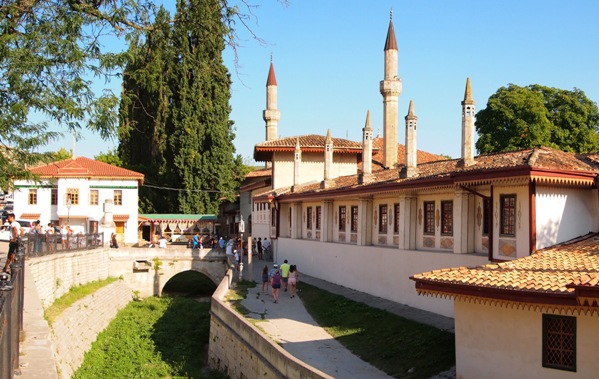
Bakhchisarai (Crimean cat. Bağçasaray, Bagchasaray) is a city in
Crimea. The administrative center of the Bakhchisarai region, which
is part of the Republic of Crimea according to the
administrative-territorial structure of Russia since 2014 (in the
Autonomous Republic of Crimea according to the
administrative-territorial division of Ukraine). Together with the
town of Nauchny, it forms the urban settlement of Bakhchisarai
(until 2014 - the Bakhchisarai City Council).
The former
capital of the Crimean Khanate and the Crimean People's Republic.
The name is translated from Crimean Tatar as “garden-palace” (bağça
/ bagcha - garden, saray / barn - palace).
By plane
The nearest airport is in Simferopol.
By train
You can get to Bakhchisarai by train from
Simferopol (about 40
minutes), from Sevastopol (about 1 hour).
Railway station,
st. Rakitsky, 1. ☎ +7 (36554) 4-26-37.
By bus
Buses run to
Sevastopol (travel time about 1 hour, every 30-60 minutes),
Simferopol (travel time about 30 minutes to the Western bus station
and 50 minutes to the railway station, traffic interval - every
20-30 minutes).
Regular fixed-route taxis and buses run from
the city to the sea coast (the villages of Uglovoe, Peschanoe,
Vilino, Beregovoe, Lyubimovka) and to other settlements of the
Bakhchisaray district, including the village of Sokolinoe.
Bus station number 1, st. Rakitskogo, 2 (on the square in front of
the railway station). ☎ +7 (36554) 4-28-25. It serves as a starting
point for buses to nearby villages.
Bus station number 2, st.
Simferopolskaya, 45 (at the entrance to the city from Simferopol,
about 2 km from the center). ☎ +7 (36554) 4-29-72. 05:10 - 20:30.
Serves all passing buses, incl. long-distance routes to the cities
of Russia and Ukraine. The station building has a left-luggage
office, a waiting room, an ATM. E-tickets can be purchased on the
carrier's website gosbus.ru.
By car
Bakhchisaray is
located on the highway Simferopol (25 km) - Sevastopol (about 30
km).
In Bakhchisarai, a picturesque road to
Yalta through
Ai-Petri also begins, along which only private vehicles can drive,
there is no scheduled service on this road.
Transport
Public transport is represented by minibuses and taxis. The most useful for tourists will be routes No. 1 and No. 2, passing Staroselye - Old City - Railway Station - New City.
Khan Palace , st. Rechnaya, 133 (from the railway station by
minibuses No. 1, 2 to the stop "Khan's Palace"). ☎ +7 (36554) 4-76-40.
🕑 Thu–Mon 9:00–17:00, ticket office closes half an hour earlier. Ticket
to the main exhibition of the museum 300 rubles, students 150 rubles,
the price includes an excursion. From April to October, you can purchase
a complex ticket for 500 rubles, which allows you to visit the main and
all additional museum exhibitions in one day. Former residence of the
Crimean khans. The only sample of the Crimean Tatar palace architecture
in the world. The fountain of tears in the Khan's palace is glorified in
Pushkin's romantic poem The Fountain of Bakhchisarai. As practice has
shown, the palace can be closed earlier than the time specified in the
schedule, without prior notice or even an announcement at the entrance.
In addition to the main exhibition, there are also several additional
ones. A ticket for each additional exhibition costs 100 rubles, students
50 rubles, excursion services in a group of more than 15 people are paid
additionally - 50 rubles / person.
Main courtyard with three
fountains of the 16th-19th centuries (open-air museum).
Art Museum.
Treasures of the Southwestern Crimea. (Only open during high season).
Baths "Sary-Gyuzel". (Only open during high season).
Khan's Lodge,
"Manuscript Koran, Tafsirs and Hadiths in the Collection of the
Museum-Reserve", Khan's Cemetery. (Only open during high season).
Falcon Tower, "Weapons in the Museum-Reserve Collection". (Only open
during high season).
Biyuk Khan-Jami Mosque. It was built in 1532 by
Sahib I Gerai, the creator of the Khan's Palace.
Tahtali-Jami Mosque.
Built in 1707 by the daughter of Khan Selim I Geray Bek Khan
Sultankhani.
Mosque "Molla Mustafa Jami". 18th century mosque
"Sphinxes" of the Churuk-Su river. Wikidata element A small river, the
Churuk-Su, flows through the entire city. Since 1964, the valley of the
Churuk-Su River has been declared a natural monument of local
significance "Natural sphinxes of the valley of the Churuk-Su River."
Where by sphinxes are meant stone formations up to twenty meters high,
which are the result of limestone weathering. The most easily accessible
cluster of "sphinxes" can be seen right above the old city.
Until 1954, Staroselye was listed as a separate village, now it is
the eastern outskirts of the city.
How to get there: from the railway
station by fixed-route taxis No. 1, 2 to the final stop Staroselye 4
Historical and architectural complex "Salachik", st. Basenko, 57
years old 9:00-17:00, ticket office closes one hour earlier. Entrance to
the territory 100 rubles.
Durbe Hadji-Gerai. Mausoleum over the
graves of the first Crimean Khan Hadji-Gerai and his son Mengli-Gerai.
Buildings of 1501
Hamam excavations. Remains of a 15th-century
hammam, which consisted of ten rooms divided into male and female
sections. The well, part of the yard and the beginning of urban
development are also visible. From the baths, only the foundation
remained, and in order to truly feel the atmosphere of the hammam from
the time of the Crimean Khanate, it is worth going to Evpatoria, where
the baths have been preserved in almost their original form.
Memorial
of Ismail Gasprinsky.
Museum. Visiting is possible only by prior
request.
Zinjirly madrasah, st. Basenko 56. A visit is possible only
by prior request at least one day before the visit, on working days
Mon-Fri. Entrance ticket 100 rubles, excursion additional 100 rubles.
Religious educational institution built in 1500. For more than four
centuries, until the Soviet era, the madrasah was the largest and most
important center of Muslim spiritual education in the Crimea. The
building was built almost from scratch in 2009 with the money of the
Turkish government, the rooms inside were restored, but they are empty.
There are no guided tours inside.
Holy Dormition Cave Monastery,
Mariampolskoye Gorge (about 800 m up the road from the final stop of
fixed-route taxis). ☎ +7 (36554) 4-74-74. The monastery was founded by
Byzantine icon worshipers no later than the 8th century. In the XIII-XIV
centuries, it ceased its activity for some time, then in the XIV century
it was revived. From the 15th to the 18th centuries The Assumption
Monastery was the main stronghold of the religious life of the Orthodox
population of Crimea. It was completely destroyed in the 1920s. It has
been revived since 1993. Monks and novices conduct free tours in the
monastery. Those who wish can go up to the Church of the Assumption of
the Most Holy Theotokos (XV century) and venerate the miraculous icon -
the main shrine of the monastery (the kerchiefs and skirts necessary for
women are at the entrance to the temple). There are restrictions on
photography in the monastery. A spring water source is available on the
square, which is popular with the people of Bakhchisaray.
Entertainment park "Crimea in miniature" (Bakhchisarai park of
miniatures) Wikidata element, Lenina street, 4. ☎ +7 (978) 0000745.
from 09:00 to 23:00 (May-September); from 09:00 to 20:00
(October-April). Adult from 13 years old: 500 rubles. Children from 3 to
13 years old: 300 rubles. The park contains all the key objects of the
peninsula.
House-Museum of Ismail Gasprinsky, st. I. Gasprinsky, 47a.
☎ +7 (36554) 47774. Tue-Fri 9:00 - 18:00, Mon 12:00 - 20:00 visiting and
organizing excursions upon prior request. Free admission, excursion - 50
rubles per person. Dedicated to the Crimean Tatar public figure and
educator Ismail Gasprinsky, who lived in the late nineteenth and early
twentieth centuries. It is located in a mansion, which previously housed
the editorial office of the newspaper "Terdzhiman - Translator", which
was founded and edited by Gasprinsky. The exposition of the museum is
not the most interesting, it presents books, documents, awards, family
photographs and memorial items of Gasprinsky.
There are several branches of the RNCB, Genbank and ChBRR banks
(almost all branches are equipped with ATMs). In addition, there are
several stand-alone ATMs.
✦ Bank "RNKB". ☎ 8 800 100-90-85.
There are 2 bank branches in the city.
st. Lenina, 42.
st. Frunze,
34.
"Genbank", st. Frunze, 26 B. ☎ 8 800 333-55-45.
Almost all cafes in the city, with rare exceptions, specialize in
Crimean Tatar cuisine. The standard menu looks like this: first courses
(shurpa, lagman, ufak-ash), second courses (sarma, manti, pilaf,
kebabs), chebureks/yantyks and a set of more familiar salads, for
dessert - several varieties of baklava. In many Crimean Tatar
establishments, alcohol is not sold.
Cheap
1 Restaurant
"Fireplace Hall", st. Schmidt, 43 (on the territory of the tourist base
"Prival"). ☎ 35 +7 (36554) 472 35. 8:00 - 23:00, but sometimes, if there
are no guests, they close at 18:00. First courses 120 rubles, second
courses 100-200 rubles. The interior is a mixture of the styles of a
gourmet restaurant and a bar from the nineties, but in general, if not
to find fault, then not bad. This is one of the cheapest establishments
in the city, moreover, this does not affect the quality of food in any
way, and it turns out to be better than most other establishments. A
large menu, mainly Russian-Ukrainian cuisine with the addition of
several Crimean Tatar dishes. Of the minuses - to get there, you need to
walk about 800 meters along an unlit street uphill from the Khan's
Palace.
2 Cafe "Crimean pasties", st. Lenina, 104. An institution
that has existed since the days of the USSR. Moreover, it seems that
time has stopped in it - it looks the same as it did 20 years ago, and
good pasties are still cooked here.
Average cost
3 Cafe
"Guzel" (Large building in the national style opposite the stop
Staroselye). Nice interior in oriental style. However, visitors often
complain about both the food and the service.
4 Cafe "Devlet-Saray",
st. Basenko, 49. The first is 250 rubles, the second is 200-350 rubles.
The chic interior of the eastern caransaray. And the staff comes across
problematic and with food as you're lucky - sometimes they bring the old
weathered, sometimes they cook fresh - and then it's pretty tasty. In
general, how lucky.
Expensive
5 Le Kafe Pushkin, st. Lenina,
106a. ☎ +7 (978) 834 98 64. Main dishes 300-800 rubles, wine 200-300
rubles per glass. Perhaps the best restaurant in the city, in winter a
fireplace is lit here, in summer a summer terrace is open. From food
they offer dishes of the Crimean Tatar, European and Japanese cuisines.
The quality of the Japanese is unknown, but the European and Crimean
Tatar ones are quite up to par. Especially delicious yantyki. The cost
is more expensive than the average for Bakhchisaray, but the food is
much better.
Coffee houses
6 Coffee house "Digermen", st.
Lenina, 71. Cakes 50-100 rubles. A small Crimean Tatar family cafe with
the right coffee on the sand and oriental sweets.
Recreation center "Prival", st. Schmidt, 43. ☎ +7 (978) 063-72-44.
Detached cottages 2300 rubles, a room in a block - 450 rubles per
person. The price includes breakfast. Old soviet tour base. Some of the
rooms are renovated, there is even a new outdoor pool. Spa treatments
are invited.
Bahitgul boutique hotel, Krasnoflotskaya st., 20. ☎ +7
(978) 868-11-82. Double from 2600 rubles. Nice hotel with an attempt to
recreate the old Crimean Tatar style. There is a swimming pool.
The Crimean mobile operators "Win Mobile" and "Volna" work. Russian
operators are in national roaming, while Ukrainian ones do not work (for
more details, see Mobile operators in Crimea).
Central Regional
Library. Pushkin, st. Lenina, 102. ☎ 4-74-01. The building was built in
1911. Inside there is an Internet center with 4 computers connected to
the Internet, free of charge.
In the same building is the Tourist
Information Center, according to reviews - extremely useless.
The valley, going east from the Assumption Monastery, was named so by
the Karaites in honor of the valley of burials near Jerusalem.
Chufut-Kale Wikidata item (from Staroselye up the road 800 m to the
Assumption Monastery, and then another 1200 m to Chufut-Kale itself).
9:00–17:00, ticket offices close 1 hour earlier. There are 2 entrances
to the fortress, where you can buy a ticket: the southern gate from the
side of the Assumption Monastery and the eastern gate, where transport
is possible, but these gates are open only in summer. Entrance ticket
adults 200 rubles, students 100 rubles. Excursion service additionally
100 rubles per person. The most famous, close and easily accessible cave
city to Bakhchisaray. The city arose in the 4th-6th centuries as a
fortified settlement on the border of the Byzantine possessions, at that
time the city was inhabited mainly by the Alans. Later, it passes under
the control of the Kipchaks and receives the name Kyrk-Er. From the 14th
century, Karaites began to settle in it, and by the time the Crimean
Khanate was formed, they most likely already made up the majority of the
city's population, this was facilitated by restrictions on their
residence in other cities of the Crimean Khanate. During the time of the
Crimean Khanate, the city became the residence of the first Khan Hadji I
Giray, but already under the next Khan Mengli I Giray, the city lost
this status, and the capital was transferred to the new city of
Salachik. Only Karaites and Krymchaks remain living in the fortress, at
the same time a new name appears near the city - “Chufut-Kale”, which
means “Jewish fortress” in the Crimean Tatra. After the annexation of
Crimea to Russia, the Karaites began to move to other cities of Crimea,
and by the end of the 19th century, only the family of the caretaker
remained to live on Chufut-Kale.
Many architectural monuments
have been preserved in the city, one of the main ones is the middle
defensive wall built in the 10-11th centuries and the other, built much
later by the Karaites in the 14-16th centuries, the eastern defensive
wall. Numerous utility rooms cut in the caves, the ruins of a mosque,
the mausoleum of the daughter of the Golden Horde Khan Tokhtamysh
Dzhanyke-khanym built in 1437 have been preserved. Also well preserved
are two Karaite kenasses of the 14th and 17th centuries and a manor
built in the 18th century, where the famous Karaite scientist A. S.
Firkovich lived, and during the tourist season an exposition dedicated
to the culture of the Karaites is shown.
Underground gallery with
a well (Closed for renovation in 2019-2020), 100 meters short of the
southern entrance to Chufut-Kale. ☎ +7 (3652) 25-63-48. 300 rubles,
children - 150 rubles, the price includes a 30-minute tour, the minimum
group is 3-5 people. The water in the fortress was imported, and during
periods of sieges, water was taken from a secret well, but information
about its exact location in the course of history was lost. It was only
in 1998 that the well was discovered not far from the southern entrance
to the fortress, in the basement of the combat tower, which was probably
part of the first line of defense of Chufut-Kale. A total of 40 people
were engaged in clearing the well from the soil for 3 years. At the same
time, at a depth of 25 meters, a side exit was discovered, gently rising
upwards. Soot inscriptions were found on the walls, made in Karaite
cursive, Latin and Aramaic script. The well was used until the 9th-10th
century, and was subsequently filled up. In addition to the main version
about the use of this hydraulic structure as a well, there is also a
version about its cult purpose.
Muslim cemetery of Gaza-Mansour.
Burials were carried out from the 15th to the 19th century, and now only
scattered gravestones remain here, some of which date back to the 15th
century. The cemetery is also notable for the fact that on its territory
there was a tekie dervish (monastery of Muslim monks) founded in the
15th century, later destroyed to the ground, and now only stone remains
of its walls can be found in its place. During the existence of the
tekie, a well was dug next to it, used for washing visitors before
prayer, later destroyed along with the tekie, but not so long ago it was
cleared and restored.
Karaite cemetery (from the Muslim cemetery
move further along the gorge. A stone arch was built at the beginning of
the cemetery). The Josaphat Valley is a traditional burial place for the
Karaites; they were brought here to be buried from afar, both from
Odessa and Vilnius. The oldest burials here date back to the 13th
century. All that remains to our time is a large number of tombstones of
varying degrees of preservation, randomly scattered around the cemetery.
The inscriptions on the tombstones are in Hebrew.
Settlement of Kyz-Kermen. For free. It is located on the top of a
mountain plateau, surrounded by steep cliffs on all sides except the
northern one. It is of interest more because of the stunning views of
the surrounding nature than because of the remains of the ancient
settlement. Only the remains of a defensive wall that barely comes to
the surface of the earth, several excavated foundations of manor
complexes and a group of four tarapans (pressure presses for grapes
carved in stone, consisting of two recesses connected to each other -
troughs) have survived. A staircase carved into the rock leading to the
foot of the plateau, to a source of drinking water and a large cistern
from the 14th-15th centuries has also been preserved.
The
settlement was protected by a defensive wall that crossed the plateau at
its narrowest point and protected the settlement from attacks from the
only vulnerable point - from the north. It was built in the 8th-9th
centuries on the remains of even earlier fortifications of the 4th-3rd
centuries. In addition to it, seven large estate complexes were
excavated on the plateau. Dwellings at that time were built of rubble
stone, fastened with clay. Presumably, up to a hundred people lived in
the settlement. The settlement reached its heyday in the VIII-IX
centuries, and ceased to exist after the establishment of the Kherson
theme in the Crimea. According to one version, Kyz-Kermen is identified
with the early medieval city of Fully.
You can get to Kyz-Kermen
either along country roads from Bakhchisaray, the road will take about
an hour and a half, or by car / bus to the village of Mashino, and from
there on foot to the crest of the mountain.
Cave town Tepe-Kermen
(7 km southeast of Bakhchisaray, and 2 km northeast of the settlement of
Kyz-Kermen). Formally paid entrance: adults 100 rubles, students 50
rubles, excursion services an additional 100 rubles per person (tickets
are sold at the central box office of the Khan's Palace), but there is
no one to check the availability of tickets. The city existed in the
period from the 6th to the 14th centuries, and reached its greatest
prosperity in the 12th-13th centuries. According to some versions, the
death of Tepe-Kermen is tied to the raid of the Golden Horde Beklyaribek
Nogay in 1299. However, it was not actually a city, they did not live
here permanently, but only hid from the enemy troops.
More than 230
artificial caves have survived to our time, as well as a cave church of
the 12th-9th centuries with carved crosses, graves, and inscriptions in
Greek. It is also still not clear from which source the inhabitants took
water. No wells have been found on the territory of Tepe-Kermen, and all
known springs are located at the very foot of the mountain.
Cave
city Bakla. For free. The northernmost cave city in the Crimea. It is
located on rocks about 300 meters high. On the territory of Bakla, in
some places you can see former streets and alleys, traces of houses,
small chapels, graves carved into the rock, the remains of grape
crushers, numerous round and rather deep utility pits, and many
artificial caves.
How to get there: from the village of Skalisty to
the left to the southeast along a dirt road - through a small forest and
an orchard. Bakla - on the crest of one of the heights of the second
mountain range, where numerous caves are visible in the rocks. You can
also go through the Alminsky (Bodraksky) quarry or, having passed it,
immediately to the left to the east to a country road and further along
a shallow valley. Sheer cliffs rise to the left, to the right, on a
sloping slope, a sparse forest grows.
Kachi-Kalyon Monastery
(above the road Bakhchisarai - Sinapnoe, between the village of
Predushchelnoye and the village of Bashtanovka, Bakhchisaray district).
9:00–17:00, the lower box office closes one hour earlier, the upper box
office closes two hours earlier. Entrance ticket adults 100 rubles,
students 50 rubles, excursion services additionally 100 rubles per
person. Medieval cave monastery. It has 250 artificial caves of
different ages and for various purposes (including economic, industrial,
residential, church and ritual). The heyday of the settlement fell on
the 8th-9th centuries. Not later than the 16th century, an Orthodox
monastery arose here (cave churches, the remains of a cemetery, as well
as the ruins of a stone fence are associated with it), which existed
until 1778. From 1851 to 1921, the hermitage of St. Anastasia operated
here.
Mangup-Kale, 20 km south-west of Bakhchisaray, near the village of
Khodja-Sala and 2 km south-east of the village of Zalesnoye. 9:00–17:00,
lower ticket office closes one hour earlier, upper ticket office - for
two. Entrance ticket adults 100 rubles, students 50 rubles, excursion
services additionally 100 rubles per person. Medieval city-fortress in
the Bakhchisaray region of Crimea. The capital of the Principality of
Theodoro Gothia, then a Turkish fortress. It is located on the top of a
remnant mountain, rising 250 m above the level of the surrounding
valleys, and 583 m above sea level and forming a plateau with an area of
about 90 hectares.
How to get there: From Sevastopol: from the bus
station "5th km" bus number 40, or number 109, to the final stop - the
village of Ternovka. Further beyond the outskirts of the village, higher
along the highway, on the left, turn onto a dirt road. On the road,
about 2 km. to the pond, Mangup-Kale - on the hill on the right. From
Simferopol: from the bus station "Zapadnaya" by minibus to the village
of Zalesnoye. Get off a little further, at a bus stop at the dam of the
reservoir near the village of Khoja-Sala, Mangup-Kale - nearby, behind
the lake. From Bakhchisarai: by bus to the village of Khoja-Sala.
Syuyren fortress (2 km from the village of Kuibyshevo, Bakhchisaray
district and 1 km from the village of Bolshoye Sadovoye). Formally paid
entrance: adults 100 rubles, students 50 rubles, excursion services an
additional 100 rubles per person (tickets are sold at the central box
office of the Khan's Palace), but there is no one to check the
availability of tickets. Founded presumably by the Byzantines in the
VI-XI centuries. Later it was part of the defensive system of the
Principality of Theodoro. The fortress controlled the valley of the
Belbek River and guarded the paths to Mangup from the north and
northeast. Destroyed in 1475 by the Turks. The remains of the fortress
walls and the tower have been preserved. Near the fortress there is a
cave monastery Chelter-Koba.
Eski-Kermen. 9:00–17:00,
the lower box office closes one hour earlier, the upper box office
closes two hours earlier. Entrance ticket adults 100 rubles, students 50
rubles, excursion service 100 rubles per person. A medieval fortified
city in the southwestern part of the Crimean peninsula, 14 km south of
the city of Bakhchisaray and 5 km northwest of the ruins of the medieval
city of Mangup-Kale. The city was founded at the end of the 6th century
AD as a Byzantine fortification and existed until the end of the XIV
century. It is one of the most visited cave cities of Crimea, after
Chufut-Kale.
How to get there: 14 km south of the city of
Bakhchisarai and 5 km northwest of the ruins of the medieval city of
Mangup-Kale; Routes to Eski-Kermen go from the villages of Kholmovka,
Zalesnoye, Ternovka, Krasny Mak, which can be reached by bus from
Bakhchisaray.
Kyz-Kule tower. A square tower with a gate is all
that remains of the fortified castle of Cherkez-Kermen, which later
received the name Kyz-Kule (Maiden's Tower). The fortification was part
of the Theodoro defense system, created in the 15th century, in addition
to Kyz-Kule, it also included the fortresses of Kalamita (on the
outskirts of modern Inkerman), Kermenchik, Sandyk-Kaya and the Chorgun
tower. All of them were located at the key points of the routes of the
alleged enemy of Theodoro - the Genoese and blocked the passages from
one valley to another.
The ruins of the Kermenchik fortress, on
Mount Fortress, half a kilometer from the village of Vysokoye. The
fortification of Kermenchik was erected in the 13th century and existed
until the Turkish conquest in 1475. It measured 150 by 50 meters and was
surrounded by a wall 4 meters high and 1.5 meters wide. The fortress was
located on a strategically important route leading to Mangup, and also
served as a shelter for the local population in case of danger. The
remains of 11 medieval churches were found in the area of the fortress,
from which it is concluded that the population of the fortress was quite
numerous.
Cave monastery Chelter-Marmara. For free.
Shuldan cave
monastery. For free.
Cave monastery Chelter-Koba. For free.
Ancient and Early Medieval Roots
Traces of human presence in the
Bakhchysarai valley date back tens of thousands of years, with
Paleolithic remains and later evidence of Cimmerians, Taurians,
Scythians, and Greek colonial influence from nearby Chersonesos. In the
early medieval period the region was inhabited by Alans, Goths, and
other groups under Byzantine influence.
A major fortified settlement
known as Qırq Yer (later Çufut Qale or Chufut-Kale, “Jewish Fortress”)
developed on a high plateau east of the modern town from roughly the
5th–6th centuries. Byzantine engineers helped fortify it for allied Alan
and Gothic populations. The site later housed Christian, Karaite Jewish,
and Muslim communities. Nearby settlements such as Eski Yurt (an
important religious and burial center) and Salaçıq (Salachik) at the
foot of the plateau also grew during the Golden Horde period (13th–15th
centuries), when Crimea formed an ulus (province) of the Mongol
successor state, with its main administrative center farther east at
Solkhat (Stary Krym).
Rise of the Crimean Khanate and Founding of
Bakhchysarai
As the Golden Horde fragmented in the 15th century, Hacı
I Giray (Haji Giray), a Chinggisid prince, established an independent
Crimean Khanate around 1441–1449. He initially based his capital at the
more defensible Qırq Yer / Salaçıq. His son Mengli I Giray continued
development there, constructing a palace, the Zindzhirli Medrese, and a
dynastic mausoleum around 1503.
In 1532 Sahib I Giray shifted the
residence downstream to a more spacious part of the Churuk-Su valley and
founded the new capital that became known as Bakhchysarai. Construction
of the Khan’s Palace (Hansaray) began at this time; the oldest surviving
structures, including the Great Khan Mosque and early baths, date to the
1530s. The open town grew around the palace complex, which combined
Crimean Tatar, Ottoman, Persian, and even some Italian architectural
elements. It functioned as the political, ceremonial, religious, and
cultural heart of the khanate.
The Khanate Era (16th–18th
Centuries)
For more than two centuries Bakhchysarai was the seat of
the Giray dynasty (descendants of Genghis Khan) and the center of
Crimean Tatar statehood. The khanate operated as an Ottoman vassal while
retaining significant autonomy, including the right to mint coinage. The
palace complex expanded over generations into a large ensemble of
courtyards, residential quarters, a harem, audience halls, mosques,
baths, stables, a cemetery with dynastic mausoleums (dürbe), gardens,
and fountains. Water features were central to the design, reflecting
both practical needs and Islamic garden ideals.
The city flourished
as a trading and craft center (notably leatherworking, metalwork, and
textiles) and a hub of Islamic learning. Key events include the Treaty
of Bakhchysarai signed in 1681, which ended the Russo-Turkish War of
1676–1681 and formalized territorial arrangements involving the Crimean
Khanate, the Ottoman Empire, and Muscovy. The town suffered raids,
including a Cossack sack in 1675 under Ivan Sirko.
In 1736, during
the Russo-Turkish War of 1735–1739, Russian forces under Field Marshal
Burkhard Christoph von Münnich captured and largely burned Bakhchysarai
and the palace. Subsequent khans, including Selamet Giray and Qırım
(Krym) Giray, rebuilt and expanded the complex in the following decades,
incorporating additional Ottoman stylistic features. One of the most
famous elements is the Fountain of Tears (Selsebil), traditionally
linked to Khan Qırım Giray’s grief over a beloved woman (often
identified in legend as Dilara Bikech). This fountain later inspired
Alexander Pushkin’s 1823 poem The Fountain of Bakhchisaray.
Russian Imperial Period (1783–1917)
After the Russo-Turkish War of
1768–1774 and internal instability, Catherine the Great annexed the
Crimean Khanate in 1783. Bakhchysarai lost its status as a capital and
became an ordinary provincial town within the Taurida Governorate. The
palace was preserved rather than demolished; Catherine herself stayed
there during her 1787 journey through the south.
Despite the
political decline, the town remained a vital cultural center for Crimean
Tatars. In the late 19th century Ismail Gasprinsky (Gaspirali) made
Bakhchysarai a focal point of the Jadid reform movement, founding the
influential newspaper Terciman (The Interpreter) in 1883 and promoting
modern education among Turkic Muslims of the Russian Empire. During the
Crimean War (1853–1856) the nearby Battle of the Alma occurred, and
Bakhchysarai functioned largely as a hospital town for Russian wounded.
Revolutionary, Soviet, and Mid-20th-Century Periods
In November
1917 the Crimean Tatar Kurultai (national congress) convened in the
Khan’s Palace and proclaimed a Crimean People’s Republic. After the
Russian Civil War the area entered the Soviet system, first as part of
the Crimean ASSR and later the Crimean Oblast (transferred from the
RSFSR to the Ukrainian SSR in 1954).
German forces occupied
Bakhchysarai from late 1941. Local Jewish populations suffered mass
killings. On 18 May 1944 the entire Crimean Tatar population of the
peninsula, including Bakhchysarai, was deported en masse to Central Asia
(the Sürgün) on accusations of collaboration with the occupiers. The
city was largely emptied of its historic Tatar majority; many mosques
and cultural sites were closed, repurposed, or neglected. Crimean Tatars
were only permitted to return in significant numbers from the late 1980s
onward.
Post-Soviet Era and Contemporary Status
With the
dissolution of the Soviet Union in 1991, Bakhchysarai became part of
independent Ukraine within the Autonomous Republic of Crimea. The return
of Crimean Tatars revived cultural life, and the Khan’s Palace complex
was developed as a major historical-cultural museum-preserve. It was
placed on UNESCO’s World Heritage Tentative List.
In 2014, following
a referendum and Russian military intervention, Crimea (including
Bakhchysarai) was incorporated into the Russian Federation as the
Republic of Crimea. The town continues to function as a district
administrative center and a key destination for visitors interested in
Crimean Tatar heritage, the palace museum, nearby cave towns (especially
Chufut-Kale), the Assumption Cave Monastery, and the surrounding
mountain landscapes.
The Khan’s Palace remains the only largely
intact example of Crimean Tatar palace architecture and the principal
material testament to the Giray dynasty and the Crimean Khanate. Its
layered history—from Paleolithic settlements and medieval fortresses
through the golden age of the khans, imperial transformation, Soviet
upheavals, and modern political changes—makes Bakhchysarai one of the
most historically dense places on the Crimean Peninsula.
Location and Administrative Setting
The town sits at approximately
44°45′ N, 33°52′ E. Under Russian administration it is the center of
Bakhchysaraysky District (Бахчисарайский район) within the Republic of
Crimea. The district covers a varied landscape that stretches from the
foothills into the higher mountain zones and includes both the town
itself and numerous surrounding villages and historical sites.
Topography and Landforms
Bakhchysarai occupies a classic Crimean
foothill setting. The town center and historic core lie in a relatively
flat, narrow valley floor at elevations of roughly 100–180 m above sea
level. Immediately to the south and southeast the terrain rises sharply
into the limestone plateaus and cuestas of the Inner Ridge. These
plateaus form steep, rocky escarpments and isolated table-like mountains
(typical Crimean “yayla” edge morphology).
Key local landforms
include:
The Churuk-Su valley itself, which is narrow and constrained
by rock walls in places.
Surrounding residual plateaus and residual
mountains such as the ridges near Chufut-Kale and the higher ground
leading toward the Main (First) Ridge farther south.
Steep rocky
slopes and cliffs that create a natural amphitheater effect around the
historic center.
The contrast between the sheltered valley floor and
the abrupt limestone uplands is one of the defining geographic features
of the site.
Hydrography
The main watercourse is the Churuk-Su
(also spelled Churuksu), a small river that flows through the town from
southeast to northwest before joining larger drainage systems that
ultimately reach the Black Sea. The river is relatively modest in volume
but historically critical: it supplied water to the Khan’s Palace
complex and the surrounding settlements, and its valley provided the
only practical route through the foothills.
Smaller seasonal streams
and springs emerge from the limestone slopes. Groundwater in the karstic
limestone is an important local resource, though surface flow can
diminish markedly in dry periods.
Geology and Soils
The area
is dominated by Cretaceous and Paleogene limestones that form the
characteristic cuestas and plateaus of the Inner Ridge. Karst processes
are active, producing caves, sinkholes, and underground drainage systems
(many of the famous cave towns and monasteries of the district are
developed in these limestones).
Valley-bottom soils are typically
alluvial and colluvial deposits of varying thickness, while the
surrounding slopes have thinner, rocky soils with significant limestone
debris. This combination supports both intensive valley agriculture
historically and more limited, drought-tolerant vegetation on the higher
ground.
Climate
Bakhchysarai has a moderately continental
climate with Mediterranean influences, modified by elevation and the
sheltering effect of the surrounding ridges:
Hot, dry summers with
average July temperatures typically in the mid-to-upper 20s °C.
Mild
winters with average January temperatures around 0 to +2 °C; snow cover
is usually thin and short-lived in the valley.
Annual precipitation
is moderate (roughly 400–550 mm in the valley, higher on the surrounding
slopes), with a tendency toward more rain in the cooler half of the year
and occasional summer droughts.
Local microclimates are pronounced:
the valley floor can be warmer and more sheltered, while the plateau
edges experience stronger winds and cooler temperatures.
Surrounding Natural Landscape
To the south the terrain rises into the
higher parts of the Crimean Mountains, eventually reaching the Main
Ridge. Northward the landscape gradually transitions toward the Crimean
foothills and the steppe zone. The district contains a mix of oak and
mixed deciduous woodlands on the lower slopes, more open steppe-like
vegetation on the plateaus, and extensive areas of limestone outcrops
with sparse, drought-adapted plant communities.
The combination of a
protected river valley, abrupt limestone relief, and proximity to higher
mountain zones has shaped both the historical development of the town
and its present-day character as a place where lowland and mountain
environments meet within a short distance.